You are here: Home > Network List > TA - USArray Transportable Network (new EarthScope stations) Stations List
> Station S32K Killisnoo, AK, USA > Earthquake Result Viewer
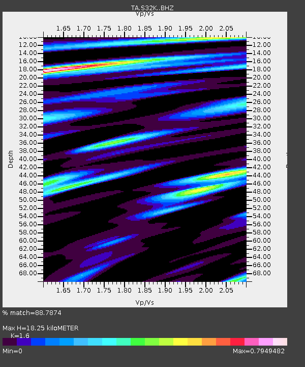
S32K Killisnoo, AK, USA - Earthquake Result Viewer
| Earthquake location: |
Afghanistan-Tajikistan Bord Reg. |
| Earthquake latitude/longitude: |
37.0/71.4 |
| Earthquake time(UTC): |
2018/05/09 (129) 10:41:45 GMT |
| Earthquake Depth: |
112 km |
| Earthquake Magnitude: |
6.2 Mww |
| Earthquake Catalog/Contributor: |
NEIC PDE/us |
|
| Network: |
TA USArray Transportable Network (new EarthScope stations) |
| Station: |
S32K Killisnoo, AK, USA |
| Lat/Lon: |
57.47 N/134.58 W |
| Elevation: |
26 m |
|
| Distance: |
83.4 deg |
| Az: |
13.767 deg |
| Baz: |
339.351 deg |
| Ray Param: |
0.045972284 |
| Estimated Moho Depth: |
18.25 km |
| Estimated Crust Vp/Vs: |
1.60 |
| Assumed Crust Vp: |
6.472 km/s |
| Estimated Crust Vs: |
4.045 km/s |
| Estimated Crust Poisson's Ratio: |
0.18 |
|
| Radial Match: |
88.7874 % |
| Radial Bump: |
400 |
| Transverse Match: |
75.70508 % |
| Transverse Bump: |
400 |
| SOD ConfigId: |
13570011 |
| Insert Time: |
2019-04-30 05:52:41.942 +0000 |
| GWidth: |
2.5 |
| Max Bumps: |
400 |
| Tol: |
0.001 |
|

Signal To Noise
| Channel | StoN | STA | LTA |
| TA:S32K: :BHZ:20180509T10:53:29.099976Z | 18.917805 | 1.503162E-6 | 7.945753E-8 |
| TA:S32K: :BHN:20180509T10:53:29.099976Z | 5.5792937 | 3.91372E-7 | 7.014723E-8 |
| TA:S32K: :BHE:20180509T10:53:29.099976Z | 3.9111662 | 3.7733315E-7 | 9.647587E-8 |
| Arrivals |
| Ps | 1.7 SECOND |
| PpPs | 7.1 SECOND |
| PsPs/PpSs | 8.9 SECOND |


