You are here: Home > Network List > TA - USArray Transportable Network (new EarthScope stations) Stations List
> Station H20A Greybull, WY, USA > Earthquake Result Viewer
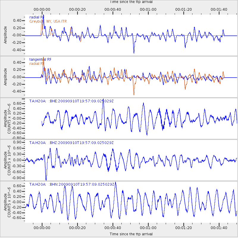
H20A Greybull, WY, USA - Earthquake Result Viewer
*The percent match for this event was below the threshold and hence no stack was calculated.
| Earthquake location: |
Easter Island Region |
| Earthquake latitude/longitude: |
-29.9/-111.8 |
| Earthquake time(UTC): |
2009/09/10 (253) 19:46:03 GMT |
| Earthquake Depth: |
10 km |
| Earthquake Magnitude: |
5.5 MW, 5.4 MB |
| Earthquake Catalog/Contributor: |
WHDF/NEIC |
|
| Network: |
TA USArray Transportable Network (new EarthScope stations) |
| Station: |
H20A Greybull, WY, USA |
| Lat/Lon: |
44.49 N/108.00 W |
| Elevation: |
1236 m |
|
| Distance: |
74.1 deg |
| Az: |
2.845 deg |
| Baz: |
183.452 deg |
| Ray Param: |
$rayparam |
*The percent match for this event was below the threshold and hence was not used in the summary stack. |
|
| Radial Match: |
64.35224 % |
| Radial Bump: |
400 |
| Transverse Match: |
38.73001 % |
| Transverse Bump: |
371 |
| SOD ConfigId: |
2622 |
| Insert Time: |
2010-03-06 11:06:22.805 +0000 |
| GWidth: |
2.5 |
| Max Bumps: |
400 |
| Tol: |
0.001 |
|
Signal To Noise
| Channel | StoN | STA | LTA |
| TA:H20A: :BHZ:20090910T19:57:09.025029Z | 1.9304706 | 4.0671515E-7 | 2.1068186E-7 |
| TA:H20A: :BHN:20090910T19:57:09.025029Z | 0.9131117 | 1.8470203E-7 | 2.0227758E-7 |
| TA:H20A: :BHE:20090910T19:57:09.025029Z | 1.8804957 | 3.4032652E-7 | 1.8097703E-7 |
| Arrivals |
| Ps | |
| PpPs | |
| PsPs/PpSs | |


