You are here: Home > Network List > TA - USArray Transportable Network (new EarthScope stations) Stations List
> Station H20A Greybull, WY, USA > Earthquake Result Viewer
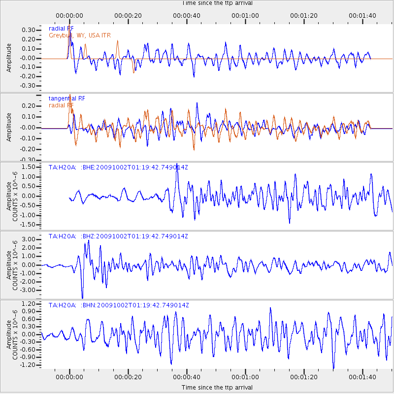
H20A Greybull, WY, USA - Earthquake Result Viewer
*The percent match for this event was below the threshold and hence no stack was calculated.
| Earthquake location: |
Tonga Islands |
| Earthquake latitude/longitude: |
-16.3/-173.5 |
| Earthquake time(UTC): |
2009/10/02 (275) 01:07:39 GMT |
| Earthquake Depth: |
8.0 km |
| Earthquake Magnitude: |
6.1 MB, 6.0 MS, 6.1 MW, 6.1 MW |
| Earthquake Catalog/Contributor: |
WHDF/NEIC |
|
| Network: |
TA USArray Transportable Network (new EarthScope stations) |
| Station: |
H20A Greybull, WY, USA |
| Lat/Lon: |
44.49 N/108.00 W |
| Elevation: |
1236 m |
|
| Distance: |
84.8 deg |
| Az: |
40.831 deg |
| Baz: |
241.29 deg |
| Ray Param: |
$rayparam |
*The percent match for this event was below the threshold and hence was not used in the summary stack. |
|
| Radial Match: |
74.31176 % |
| Radial Bump: |
400 |
| Transverse Match: |
73.51377 % |
| Transverse Bump: |
400 |
| SOD ConfigId: |
2622 |
| Insert Time: |
2010-03-06 11:06:32.650 +0000 |
| GWidth: |
2.5 |
| Max Bumps: |
400 |
| Tol: |
0.001 |
|
Signal To Noise
| Channel | StoN | STA | LTA |
| TA:H20A: :BHZ:20091002T01:19:42.749014Z | 8.2408695 | 1.2203992E-6 | 1.4809108E-7 |
| TA:H20A: :BHN:20091002T01:19:42.749014Z | 1.2028122 | 1.961739E-7 | 1.6309605E-7 |
| TA:H20A: :BHE:20091002T01:19:42.749014Z | 1.8031231 | 3.0521272E-7 | 1.6926893E-7 |
| Arrivals |
| Ps | |
| PpPs | |
| PsPs/PpSs | |


