You are here: Home > Network List > TA - USArray Transportable Network (new EarthScope stations) Stations List
> Station H20A Greybull, WY, USA > Earthquake Result Viewer
H20A Greybull, WY, USA - Earthquake Result Viewer
*The percent match for this event was below the threshold and hence no stack was calculated.
| Earthquake location: |
Sea Of Okhotsk |
| Earthquake latitude/longitude: |
54.2/154.3 |
| Earthquake time(UTC): |
2008/11/24 (329) 09:02:58 GMT |
| Earthquake Depth: |
492 km |
| Earthquake Magnitude: |
6.5 MB, 7.3 MW, 7.3 MW |
| Earthquake Catalog/Contributor: |
WHDF/NEIC |
|
| Network: |
TA USArray Transportable Network (new EarthScope stations) |
| Station: |
H20A Greybull, WY, USA |
| Lat/Lon: |
44.49 N/108.00 W |
| Elevation: |
1236 m |
|
| Distance: |
59.4 deg |
| Az: |
55.491 deg |
| Baz: |
317.439 deg |
| Ray Param: |
$rayparam |
*The percent match for this event was below the threshold and hence was not used in the summary stack. |
|
| Radial Match: |
77.59943 % |
| Radial Bump: |
400 |
| Transverse Match: |
65.24723 % |
| Transverse Bump: |
400 |
| SOD ConfigId: |
2658 |
| Insert Time: |
2010-03-06 11:06:43.648 +0000 |
| GWidth: |
2.5 |
| Max Bumps: |
400 |
| Tol: |
0.001 |
|
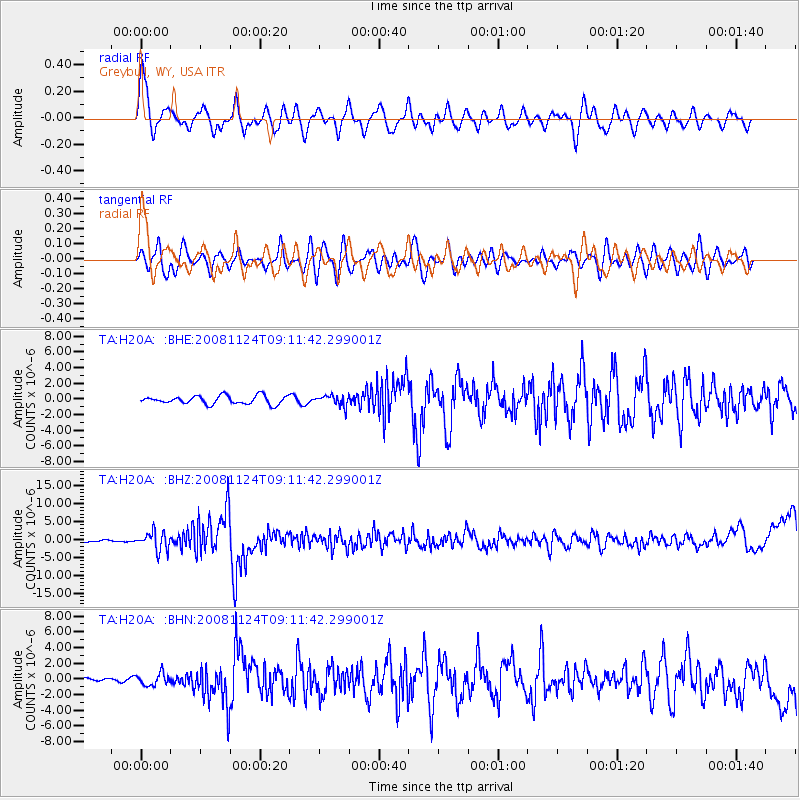
Signal To Noise
| Channel | StoN | STA | LTA |
| TA:H20A: :BHZ:20081124T09:11:42.299001Z | 8.760167 | 2.520958E-6 | 2.8777512E-7 |
| TA:H20A: :BHN:20081124T09:11:42.299001Z | 1.2823663 | 7.791499E-7 | 6.075876E-7 |
| TA:H20A: :BHE:20081124T09:11:42.299001Z | 1.2467122 | 6.611476E-7 | 5.3031295E-7 |
| Arrivals |
| Ps | |
| PpPs | |
| PsPs/PpSs | |


