You are here: Home > Network List > TA - USArray Transportable Network (new EarthScope stations) Stations List
> Station H20A Greybull, WY, USA > Earthquake Result Viewer
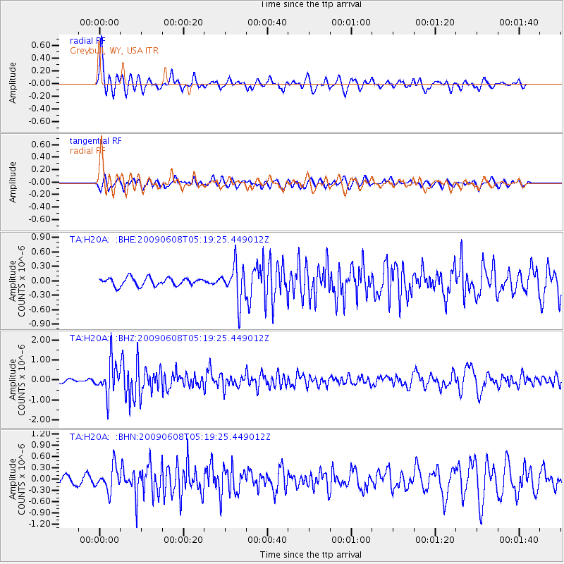
H20A Greybull, WY, USA - Earthquake Result Viewer
*The percent match for this event was below the threshold and hence no stack was calculated.
| Earthquake location: |
Honduras |
| Earthquake latitude/longitude: |
15.8/-86.9 |
| Earthquake time(UTC): |
2009/06/08 (159) 05:13:14 GMT |
| Earthquake Depth: |
10 km |
| Earthquake Magnitude: |
5.5 MB, 4.9 MS, 5.4 MW, 5.4 MW |
| Earthquake Catalog/Contributor: |
WHDF/NEIC |
|
| Network: |
TA USArray Transportable Network (new EarthScope stations) |
| Station: |
H20A Greybull, WY, USA |
| Lat/Lon: |
44.49 N/108.00 W |
| Elevation: |
1236 m |
|
| Distance: |
33.7 deg |
| Az: |
332.31 deg |
| Baz: |
141.316 deg |
| Ray Param: |
$rayparam |
*The percent match for this event was below the threshold and hence was not used in the summary stack. |
|
| Radial Match: |
78.05623 % |
| Radial Bump: |
400 |
| Transverse Match: |
67.583244 % |
| Transverse Bump: |
400 |
| SOD ConfigId: |
2648 |
| Insert Time: |
2010-03-06 11:06:56.989 +0000 |
| GWidth: |
2.5 |
| Max Bumps: |
400 |
| Tol: |
0.001 |
|
Signal To Noise
| Channel | StoN | STA | LTA |
| TA:H20A: :BHZ:20090608T05:19:25.449012Z | 14.430462 | 8.3490164E-7 | 5.785689E-8 |
| TA:H20A: :BHN:20090608T05:19:25.449012Z | 2.7256887 | 3.3110996E-7 | 1.2147754E-7 |
| TA:H20A: :BHE:20090608T05:19:25.449012Z | 4.689976 | 3.800869E-7 | 8.1042394E-8 |
| Arrivals |
| Ps | |
| PpPs | |
| PsPs/PpSs | |


