You are here: Home > Network List > US - United States National Seismic Network Stations List
> Station HDIL Hopedale, Illinois, USA > Earthquake Result Viewer
HDIL Hopedale, Illinois, USA - Earthquake Result Viewer
| Earthquake location: |
Near Coast Of Ecuador |
| Earthquake latitude/longitude: |
0.4/-79.8 |
| Earthquake time(UTC): |
2016/05/18 (139) 07:57:05 GMT |
| Earthquake Depth: |
32 km |
| Earthquake Magnitude: |
6.7 MWP, 6.7 MWW, 6.7 MI |
| Earthquake Catalog/Contributor: |
NEIC PDE/NEIC COMCAT |
|
| Network: |
US United States National Seismic Network |
| Station: |
HDIL Hopedale, Illinois, USA |
| Lat/Lon: |
40.56 N/89.29 W |
| Elevation: |
219 m |
|
| Distance: |
40.9 deg |
| Az: |
348.886 deg |
| Baz: |
165.346 deg |
| Ray Param: |
0.074080765 |
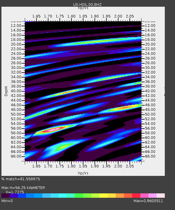
| Estimated Moho Depth: |
56.25 km |
| Estimated Crust Vp/Vs: |
1.73 |
| Assumed Crust Vp: |
6.498 km/s |
| Estimated Crust Vs: |
3.761 km/s |
| Estimated Crust Poisson's Ratio: |
0.25 |
|
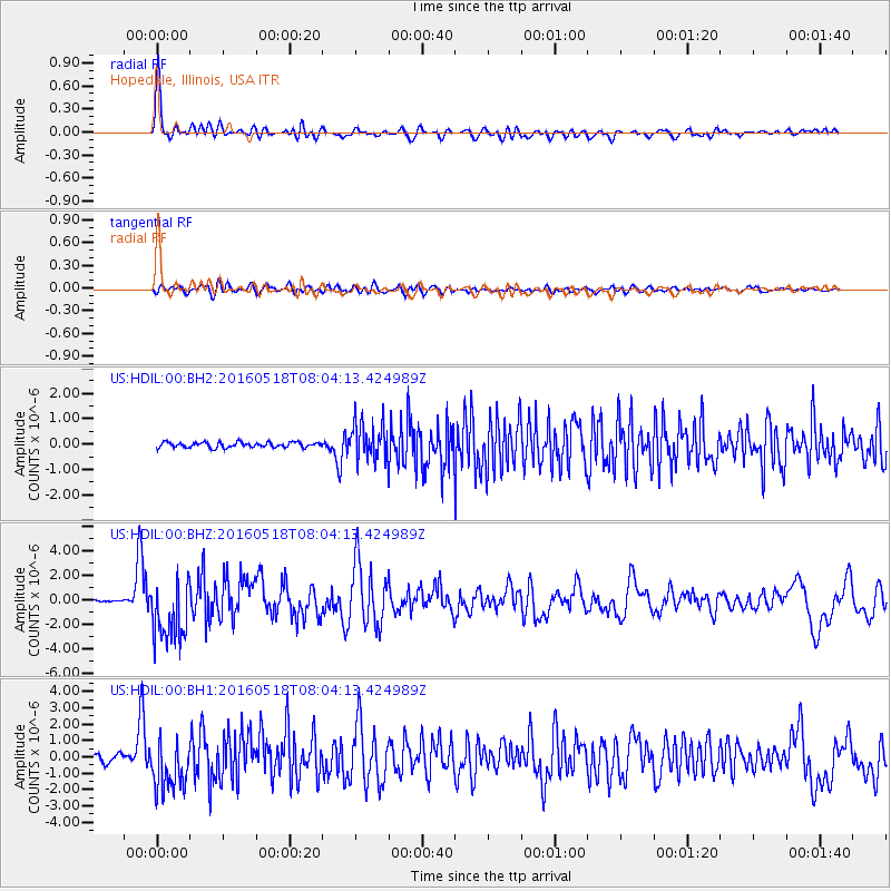
| Radial Match: |
91.559975 % |
| Radial Bump: |
400 |
| Transverse Match: |
71.33928 % |
| Transverse Bump: |
400 |
| SOD ConfigId: |
1475611 |
| Insert Time: |
2016-06-01 08:16:06.282 +0000 |
| GWidth: |
2.5 |
| Max Bumps: |
400 |
| Tol: |
0.001 |
|
Signal To Noise
| Channel | StoN | STA | LTA |
| US:HDIL:00:BHZ:20160518T08:04:13.424989Z | 32.20634 | 2.5760903E-6 | 7.998705E-8 |
| US:HDIL:00:BH1:20160518T08:04:13.424989Z | 8.52958 | 1.5446531E-6 | 1.8109368E-7 |
| US:HDIL:00:BH2:20160518T08:04:13.424989Z | 7.0058346 | 7.3007357E-7 | 1.0420937E-7 |
| Arrivals |
| Ps | 6.8 SECOND |
| PpPs | 22 SECOND |
| PsPs/PpSs | 29 SECOND |


