You are here: Home > Network List > TA - USArray Transportable Network (new EarthScope stations) Stations List
> Station H20A Greybull, WY, USA > Earthquake Result Viewer
H20A Greybull, WY, USA - Earthquake Result Viewer
*The percent match for this event was below the threshold and hence no stack was calculated.
| Earthquake location: |
Northern Mid-Atlantic Ridge |
| Earthquake latitude/longitude: |
13.4/-44.8 |
| Earthquake time(UTC): |
2008/12/07 (342) 06:23:09 GMT |
| Earthquake Depth: |
10 km |
| Earthquake Magnitude: |
5.6 MB, 5.3 MS, 5.7 MW |
| Earthquake Catalog/Contributor: |
WHDF/NEIC |
|
| Network: |
TA USArray Transportable Network (new EarthScope stations) |
| Station: |
H20A Greybull, WY, USA |
| Lat/Lon: |
44.49 N/108.00 W |
| Elevation: |
1236 m |
|
| Distance: |
61.7 deg |
| Az: |
313.475 deg |
| Baz: |
99.319 deg |
| Ray Param: |
$rayparam |
*The percent match for this event was below the threshold and hence was not used in the summary stack. |
|
| Radial Match: |
70.02242 % |
| Radial Bump: |
400 |
| Transverse Match: |
69.45835 % |
| Transverse Bump: |
400 |
| SOD ConfigId: |
2658 |
| Insert Time: |
2010-03-06 11:06:58.666 +0000 |
| GWidth: |
2.5 |
| Max Bumps: |
400 |
| Tol: |
0.001 |
|
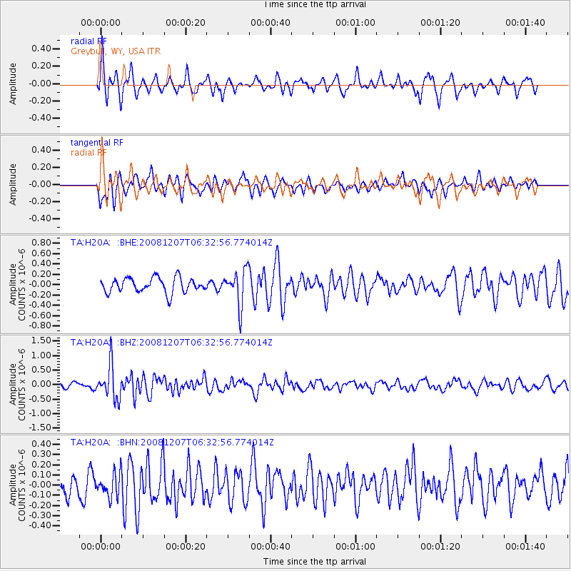
Signal To Noise
| Channel | StoN | STA | LTA |
| TA:H20A: :BHZ:20081207T06:32:56.774014Z | 4.3180256 | 5.9556123E-7 | 1.3792443E-7 |
| TA:H20A: :BHN:20081207T06:32:56.774014Z | 0.9961416 | 1.18924E-7 | 1.1938464E-7 |
| TA:H20A: :BHE:20081207T06:32:56.774014Z | 2.4743469 | 3.5483754E-7 | 1.4340655E-7 |
| Arrivals |
| Ps | |
| PpPs | |
| PsPs/PpSs | |


