You are here: Home > Network List > TA - USArray Transportable Network (new EarthScope stations) Stations List
> Station H20A Greybull, WY, USA > Earthquake Result Viewer
H20A Greybull, WY, USA - Earthquake Result Viewer
*The percent match for this event was below the threshold and hence no stack was calculated.
| Earthquake location: |
Eastern Kazakhstan |
| Earthquake latitude/longitude: |
44.7/78.9 |
| Earthquake time(UTC): |
2009/06/13 (164) 17:17:38 GMT |
| Earthquake Depth: |
14 km |
| Earthquake Magnitude: |
5.8 MB, 5.1 MS, 5.4 MW, 5.4 MW |
| Earthquake Catalog/Contributor: |
WHDF/NEIC |
|
| Network: |
TA USArray Transportable Network (new EarthScope stations) |
| Station: |
H20A Greybull, WY, USA |
| Lat/Lon: |
44.49 N/108.00 W |
| Elevation: |
1236 m |
|
| Distance: |
91.0 deg |
| Az: |
4.907 deg |
| Baz: |
355.113 deg |
| Ray Param: |
$rayparam |
*The percent match for this event was below the threshold and hence was not used in the summary stack. |
|
| Radial Match: |
57.05112 % |
| Radial Bump: |
400 |
| Transverse Match: |
58.7136 % |
| Transverse Bump: |
400 |
| SOD ConfigId: |
2648 |
| Insert Time: |
2010-03-06 11:07:02.947 +0000 |
| GWidth: |
2.5 |
| Max Bumps: |
400 |
| Tol: |
0.001 |
|
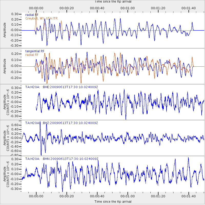
Signal To Noise
| Channel | StoN | STA | LTA |
| TA:H20A: :BHZ:20090613T17:30:10.024009Z | 3.654559 | 3.088779E-7 | 8.451852E-8 |
| TA:H20A: :BHN:20090613T17:30:10.024009Z | 1.1230358 | 9.2133234E-8 | 8.203945E-8 |
| TA:H20A: :BHE:20090613T17:30:10.024009Z | 0.7487469 | 7.1743386E-8 | 9.5817946E-8 |
| Arrivals |
| Ps | |
| PpPs | |
| PsPs/PpSs | |


