You are here: Home > Network List > TA - USArray Transportable Network (new EarthScope stations) Stations List
> Station H20A Greybull, WY, USA > Earthquake Result Viewer
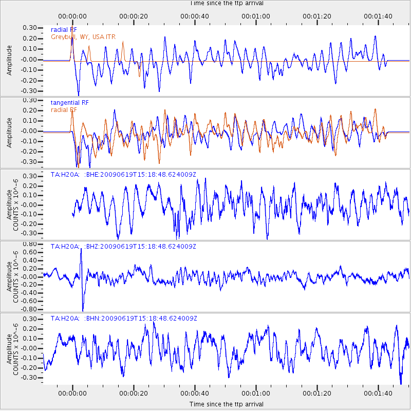
H20A Greybull, WY, USA - Earthquake Result Viewer
*The percent match for this event was below the threshold and hence no stack was calculated.
| Earthquake location: |
Mariana Islands |
| Earthquake latitude/longitude: |
14.1/145.2 |
| Earthquake time(UTC): |
2009/06/19 (170) 15:06:24 GMT |
| Earthquake Depth: |
114 km |
| Earthquake Magnitude: |
5.5 MB, 5.5 MW |
| Earthquake Catalog/Contributor: |
WHDF/NEIC |
|
| Network: |
TA USArray Transportable Network (new EarthScope stations) |
| Station: |
H20A Greybull, WY, USA |
| Lat/Lon: |
44.49 N/108.00 W |
| Elevation: |
1236 m |
|
| Distance: |
91.8 deg |
| Az: |
43.277 deg |
| Baz: |
291.664 deg |
| Ray Param: |
$rayparam |
*The percent match for this event was below the threshold and hence was not used in the summary stack. |
|
| Radial Match: |
45.024925 % |
| Radial Bump: |
400 |
| Transverse Match: |
70.22848 % |
| Transverse Bump: |
400 |
| SOD ConfigId: |
2648 |
| Insert Time: |
2010-03-06 11:07:05.194 +0000 |
| GWidth: |
2.5 |
| Max Bumps: |
400 |
| Tol: |
0.001 |
|
Signal To Noise
| Channel | StoN | STA | LTA |
| TA:H20A: :BHZ:20090619T15:18:48.624009Z | 3.4714892 | 3.245907E-7 | 9.350187E-8 |
| TA:H20A: :BHN:20090619T15:18:48.624009Z | 0.8165744 | 1.0156972E-7 | 1.2438514E-7 |
| TA:H20A: :BHE:20090619T15:18:48.624009Z | 0.96671313 | 1.2670162E-7 | 1.3106435E-7 |
| Arrivals |
| Ps | |
| PpPs | |
| PsPs/PpSs | |


