You are here: Home > Network List > TA - USArray Transportable Network (new EarthScope stations) Stations List
> Station H20A Greybull, WY, USA > Earthquake Result Viewer
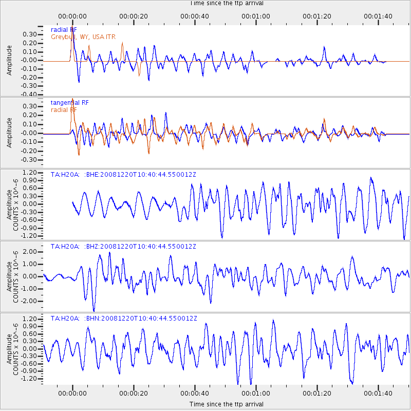
H20A Greybull, WY, USA - Earthquake Result Viewer
*The percent match for this event was below the threshold and hence no stack was calculated.
| Earthquake location: |
Off East Coast Of Honshu, Japan |
| Earthquake latitude/longitude: |
36.5/142.4 |
| Earthquake time(UTC): |
2008/12/20 (355) 10:29:23 GMT |
| Earthquake Depth: |
19 km |
| Earthquake Magnitude: |
6.0 MB, 6.3 MS, 6.3 MW, 6.3 MW |
| Earthquake Catalog/Contributor: |
WHDF/NEIC |
|
| Network: |
TA USArray Transportable Network (new EarthScope stations) |
| Station: |
H20A Greybull, WY, USA |
| Lat/Lon: |
44.49 N/108.00 W |
| Elevation: |
1236 m |
|
| Distance: |
77.2 deg |
| Az: |
43.746 deg |
| Baz: |
308.922 deg |
| Ray Param: |
$rayparam |
*The percent match for this event was below the threshold and hence was not used in the summary stack. |
|
| Radial Match: |
65.24985 % |
| Radial Bump: |
327 |
| Transverse Match: |
70.72865 % |
| Transverse Bump: |
321 |
| SOD ConfigId: |
2658 |
| Insert Time: |
2010-03-06 11:07:13.690 +0000 |
| GWidth: |
2.5 |
| Max Bumps: |
400 |
| Tol: |
0.001 |
|
Signal To Noise
| Channel | StoN | STA | LTA |
| TA:H20A: :BHZ:20081220T10:40:44.550012Z | 4.204558 | 7.631134E-7 | 1.8149672E-7 |
| TA:H20A: :BHN:20081220T10:40:44.550012Z | 1.4304886 | 3.988149E-7 | 2.7879628E-7 |
| TA:H20A: :BHE:20081220T10:40:44.550012Z | 0.63113195 | 1.7435133E-7 | 2.762518E-7 |
| Arrivals |
| Ps | |
| PpPs | |
| PsPs/PpSs | |


