You are here: Home > Network List > US - United States National Seismic Network Stations List
> Station LKWY Lake (Yellowstone--Lake), Wyoming, USA > Earthquake Result Viewer
LKWY Lake (Yellowstone--Lake), Wyoming, USA - Earthquake Result Viewer

| Earthquake location: |
Near Coast Of Ecuador |
| Earthquake latitude/longitude: |
0.4/-79.8 |
| Earthquake time(UTC): |
2016/05/18 (139) 07:57:05 GMT |
| Earthquake Depth: |
32 km |
| Earthquake Magnitude: |
6.7 MWP, 6.7 MWW, 6.7 MI |
| Earthquake Catalog/Contributor: |
NEIC PDE/NEIC COMCAT |
|
| Network: |
US United States National Seismic Network |
| Station: |
LKWY Lake (Yellowstone--Lake), Wyoming, USA |
| Lat/Lon: |
44.57 N/110.40 W |
| Elevation: |
2424 m |
|
| Distance: |
51.7 deg |
| Az: |
332.333 deg |
| Baz: |
139.49 deg |
| Ray Param: |
0.06720175 |
| Estimated Moho Depth: |
29.0 km |
| Estimated Crust Vp/Vs: |
1.68 |
| Assumed Crust Vp: |
6.35 km/s |
| Estimated Crust Vs: |
3.774 km/s |
| Estimated Crust Poisson's Ratio: |
0.23 |
|
| Radial Match: |
83.524376 % |
| Radial Bump: |
400 |
| Transverse Match: |
72.1844 % |
| Transverse Bump: |
400 |
| SOD ConfigId: |
1475611 |
| Insert Time: |
2016-06-01 08:16:55.003 +0000 |
| GWidth: |
2.5 |
| Max Bumps: |
400 |
| Tol: |
0.001 |
|
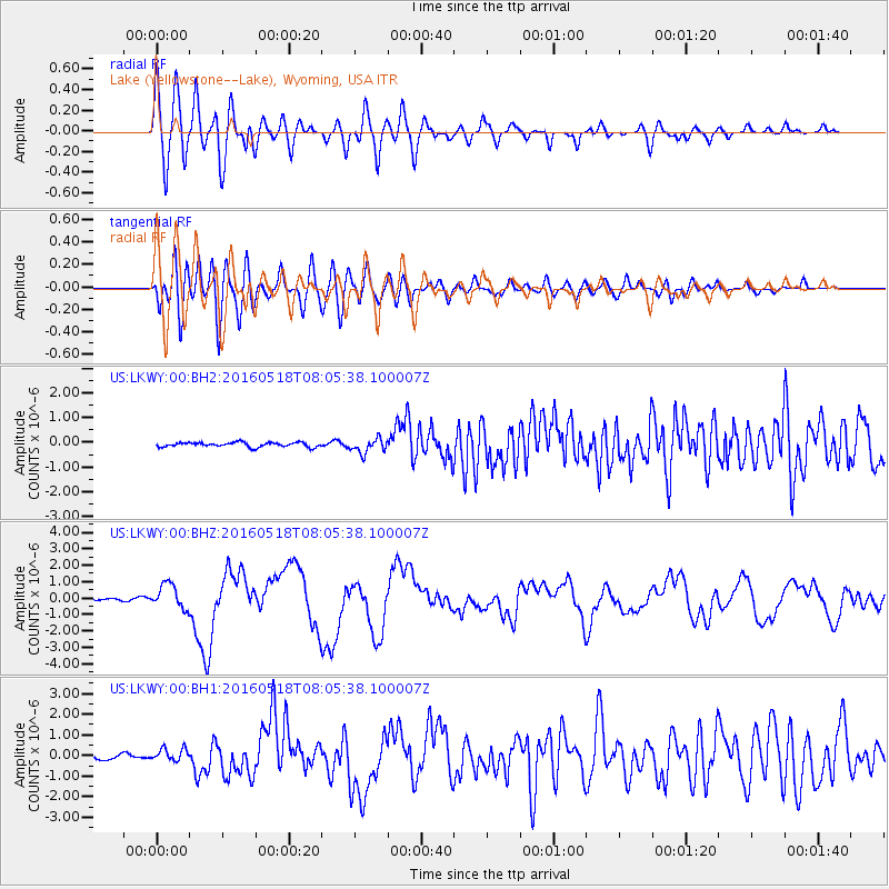
Signal To Noise
| Channel | StoN | STA | LTA |
| US:LKWY:00:BHZ:20160518T08:05:38.100007Z | 9.21585 | 7.4868495E-7 | 8.123884E-8 |
| US:LKWY:00:BH1:20160518T08:05:38.100007Z | 2.1818967 | 2.9645295E-7 | 1.3586937E-7 |
| US:LKWY:00:BH2:20160518T08:05:38.100007Z | 3.1223395 | 2.9001353E-7 | 9.2883404E-8 |
| Arrivals |
| Ps | 3.3 SECOND |
| PpPs | 12 SECOND |
| PsPs/PpSs | 15 SECOND |


