You are here: Home > Network List > CI - Caltech Regional Seismic Network Stations List
> Station TOV Thousand Oaks, California, USA > Earthquake Result Viewer
TOV Thousand Oaks, California, USA - Earthquake Result Viewer
| Earthquake location: |
Southern Bolivia |
| Earthquake latitude/longitude: |
-20.1/-65.2 |
| Earthquake time(UTC): |
2003/07/27 (208) 11:41:27 GMT |
| Earthquake Depth: |
345 km |
| Earthquake Magnitude: |
5.9 MB, 6.0 MW, 6.0 MW |
| Earthquake Catalog/Contributor: |
WHDF/NEIC |
|
| Network: |
CI Caltech Regional Seismic Network |
| Station: |
TOV Thousand Oaks, California, USA |
| Lat/Lon: |
34.16 N/118.82 W |
| Elevation: |
50 m |
|
| Distance: |
74.3 deg |
| Az: |
316.079 deg |
| Baz: |
128.187 deg |
| Ray Param: |
0.051438417 |
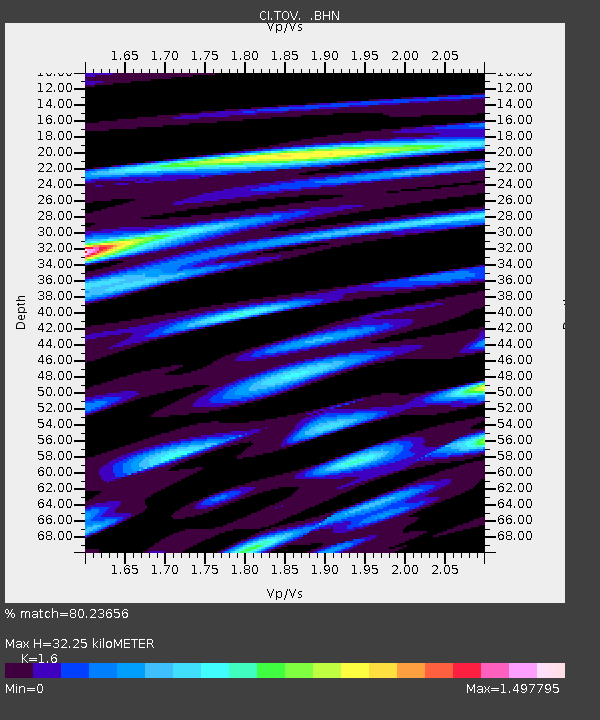
| Estimated Moho Depth: |
32.25 km |
| Estimated Crust Vp/Vs: |
1.60 |
| Assumed Crust Vp: |
6.1 km/s |
| Estimated Crust Vs: |
3.812 km/s |
| Estimated Crust Poisson's Ratio: |
0.18 |
|
| Radial Match: |
80.23656 % |
| Radial Bump: |
400 |
| Transverse Match: |
77.44956 % |
| Transverse Bump: |
400 |
| SOD ConfigId: |
3787 |
| Insert Time: |
2010-02-26 01:57:27.504 +0000 |
| GWidth: |
2.5 |
| Max Bumps: |
400 |
| Tol: |
0.001 |
|

Signal To Noise
| Channel | StoN | STA | LTA |
| CI:TOV: :BHN:20030727T11:51:56.260022Z | 1.3539866 | 2.8952593E-7 | 2.1383218E-7 |
| CI:TOV: :BHE:20030727T11:51:56.260022Z | 2.823985 | 4.6288253E-7 | 1.6391111E-7 |
| CI:TOV: :BHZ:20030727T11:51:56.260022Z | 8.770046 | 1.2793636E-6 | 1.4587876E-7 |
| Arrivals |
| Ps | 3.3 SECOND |
| PpPs | 13 SECOND |
| PsPs/PpSs | 17 SECOND |


