You are here: Home > Network List > US - United States National Seismic Network Stations List
> Station LONY Lake Ozonia, New York, USA > Earthquake Result Viewer
LONY Lake Ozonia, New York, USA - Earthquake Result Viewer
| Earthquake location: |
Near Coast Of Ecuador |
| Earthquake latitude/longitude: |
0.4/-79.8 |
| Earthquake time(UTC): |
2016/05/18 (139) 07:57:05 GMT |
| Earthquake Depth: |
32 km |
| Earthquake Magnitude: |
6.7 MWP, 6.7 MWW, 6.7 MI |
| Earthquake Catalog/Contributor: |
NEIC PDE/NEIC COMCAT |
|
| Network: |
US United States National Seismic Network |
| Station: |
LONY Lake Ozonia, New York, USA |
| Lat/Lon: |
44.62 N/74.58 W |
| Elevation: |
440 m |
|
| Distance: |
44.2 deg |
| Az: |
5.305 deg |
| Baz: |
187.438 deg |
| Ray Param: |
0.07197484 |
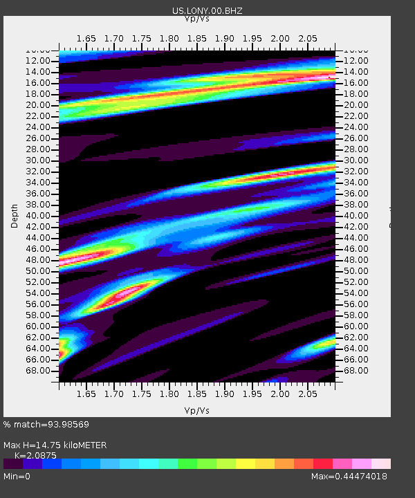
| Estimated Moho Depth: |
14.75 km |
| Estimated Crust Vp/Vs: |
2.09 |
| Assumed Crust Vp: |
6.419 km/s |
| Estimated Crust Vs: |
3.075 km/s |
| Estimated Crust Poisson's Ratio: |
0.35 |
|
| Radial Match: |
93.98569 % |
| Radial Bump: |
307 |
| Transverse Match: |
86.68476 % |
| Transverse Bump: |
400 |
| SOD ConfigId: |
1475611 |
| Insert Time: |
2016-06-01 08:17:05.608 +0000 |
| GWidth: |
2.5 |
| Max Bumps: |
400 |
| Tol: |
0.001 |
|
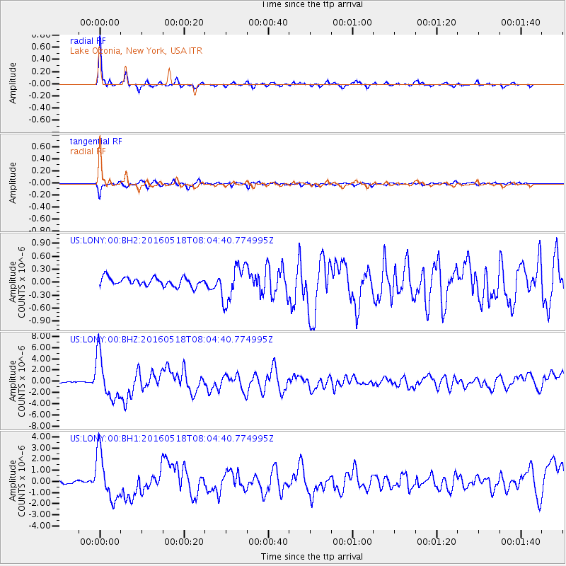
Signal To Noise
| Channel | StoN | STA | LTA |
| US:LONY:00:BHZ:20160518T08:04:40.774995Z | 31.562656 | 3.917293E-6 | 1.2411162E-7 |
| US:LONY:00:BH1:20160518T08:04:40.774995Z | 14.403996 | 2.1248527E-6 | 1.4751826E-7 |
| US:LONY:00:BH2:20160518T08:04:40.774995Z | 4.3508162 | 4.2562482E-7 | 9.782643E-8 |
| Arrivals |
| Ps | 2.6 SECOND |
| PpPs | 6.7 SECOND |
| PsPs/PpSs | 9.4 SECOND |


