You are here: Home > Network List > TA - USArray Transportable Network (new EarthScope stations) Stations List
> Station H20A Greybull, WY, USA > Earthquake Result Viewer
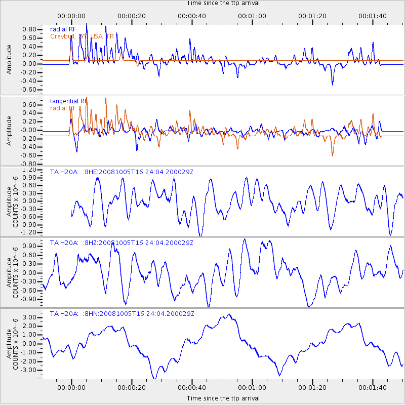
H20A Greybull, WY, USA - Earthquake Result Viewer
*The percent match for this event was below the threshold and hence no stack was calculated.
| Earthquake location: |
Tajikistan-Xinjiang Border Reg. |
| Earthquake latitude/longitude: |
39.5/73.9 |
| Earthquake time(UTC): |
2008/10/05 (279) 16:11:10 GMT |
| Earthquake Depth: |
35 km |
| Earthquake Magnitude: |
5.6 MB |
| Earthquake Catalog/Contributor: |
WHDF/NEIC |
|
| Network: |
TA USArray Transportable Network (new EarthScope stations) |
| Station: |
H20A Greybull, WY, USA |
| Lat/Lon: |
44.49 N/108.00 W |
| Elevation: |
1236 m |
|
| Distance: |
96.4 deg |
| Az: |
1.359 deg |
| Baz: |
358.531 deg |
| Ray Param: |
$rayparam |
*The percent match for this event was below the threshold and hence was not used in the summary stack. |
|
| Radial Match: |
49.15469 % |
| Radial Bump: |
302 |
| Transverse Match: |
63.659557 % |
| Transverse Bump: |
351 |
| SOD ConfigId: |
2556 |
| Insert Time: |
2010-03-06 11:07:33.940 +0000 |
| GWidth: |
2.5 |
| Max Bumps: |
400 |
| Tol: |
0.001 |
|
Signal To Noise
| Channel | StoN | STA | LTA |
| TA:H20A: :BHZ:20081005T16:24:04.200029Z | 1.2504307 | 4.6099902E-7 | 3.6867218E-7 |
| TA:H20A: :BHN:20081005T16:24:04.200029Z | 1.1858886 | 7.758176E-7 | 6.5420784E-7 |
| TA:H20A: :BHE:20081005T16:24:04.200029Z | 0.95021695 | 4.48813E-7 | 4.723269E-7 |
| Arrivals |
| Ps | |
| PpPs | |
| PsPs/PpSs | |


