You are here: Home > Network List > TA - USArray Transportable Network (new EarthScope stations) Stations List
> Station H20A Greybull, WY, USA > Earthquake Result Viewer
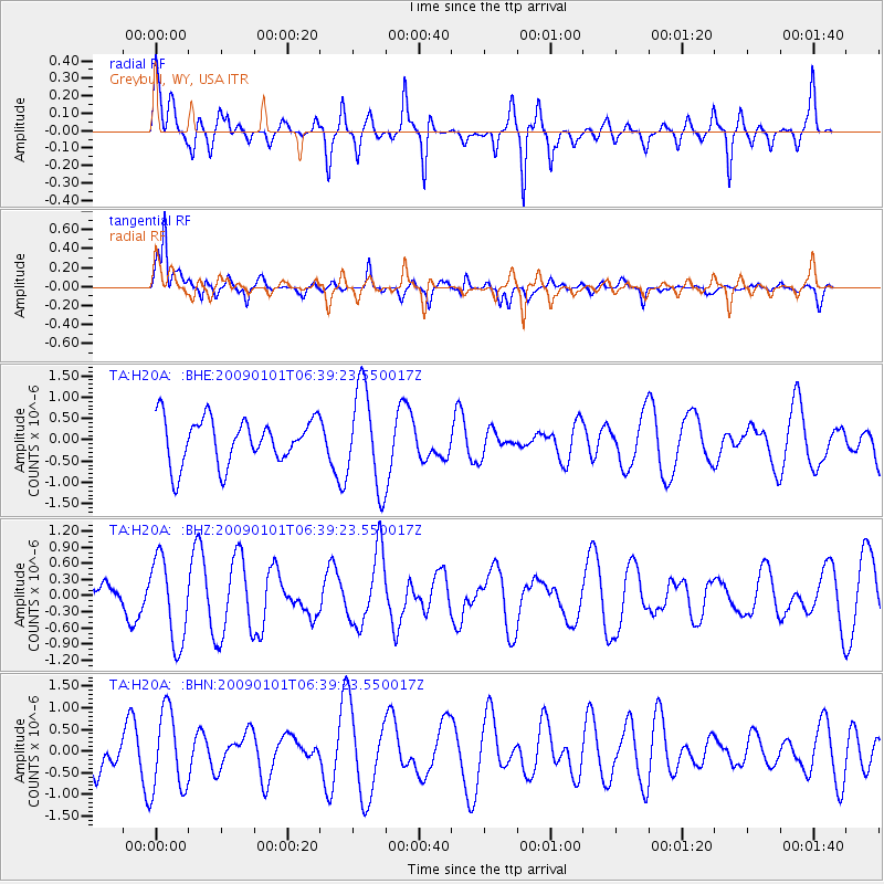
H20A Greybull, WY, USA - Earthquake Result Viewer
*The percent match for this event was below the threshold and hence no stack was calculated.
| Earthquake location: |
Southern East Pacific Rise |
| Earthquake latitude/longitude: |
-34.8/-107.6 |
| Earthquake time(UTC): |
2009/01/01 (001) 06:27:51 GMT |
| Earthquake Depth: |
10 km |
| Earthquake Magnitude: |
5.8 MW, 5.2 MS, 5.1 MB, 5.8 MW |
| Earthquake Catalog/Contributor: |
WHDF/NEIC |
|
| Network: |
TA USArray Transportable Network (new EarthScope stations) |
| Station: |
H20A Greybull, WY, USA |
| Lat/Lon: |
44.49 N/108.00 W |
| Elevation: |
1236 m |
|
| Distance: |
79.0 deg |
| Az: |
359.743 deg |
| Baz: |
179.705 deg |
| Ray Param: |
$rayparam |
*The percent match for this event was below the threshold and hence was not used in the summary stack. |
|
| Radial Match: |
47.883484 % |
| Radial Bump: |
400 |
| Transverse Match: |
71.54241 % |
| Transverse Bump: |
400 |
| SOD ConfigId: |
2834 |
| Insert Time: |
2010-03-06 11:07:37.538 +0000 |
| GWidth: |
2.5 |
| Max Bumps: |
400 |
| Tol: |
0.001 |
|
Signal To Noise
| Channel | StoN | STA | LTA |
| TA:H20A: :BHZ:20090101T06:39:23.550017Z | 1.3512813 | 7.8045855E-7 | 5.7756927E-7 |
| TA:H20A: :BHN:20090101T06:39:23.550017Z | 1.6869297 | 9.2555035E-7 | 5.4865967E-7 |
| TA:H20A: :BHE:20090101T06:39:23.550017Z | 2.1580613 | 1.1486328E-6 | 5.322522E-7 |
| Arrivals |
| Ps | |
| PpPs | |
| PsPs/PpSs | |


