You are here: Home > Network List > TA - USArray Transportable Network (new EarthScope stations) Stations List
> Station H20A Greybull, WY, USA > Earthquake Result Viewer
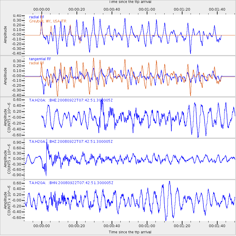
H20A Greybull, WY, USA - Earthquake Result Viewer
*The percent match for this event was below the threshold and hence no stack was calculated.
| Earthquake location: |
Hokkaido, Japan Region |
| Earthquake latitude/longitude: |
41.6/140.4 |
| Earthquake time(UTC): |
2008/09/22 (266) 07:31:59 GMT |
| Earthquake Depth: |
149 km |
| Earthquake Magnitude: |
5.7 MW, 5.3 MB, 5.6 MW |
| Earthquake Catalog/Contributor: |
WHDF/NEIC |
|
| Network: |
TA USArray Transportable Network (new EarthScope stations) |
| Station: |
H20A Greybull, WY, USA |
| Lat/Lon: |
44.49 N/108.00 W |
| Elevation: |
1236 m |
|
| Distance: |
74.7 deg |
| Az: |
43.654 deg |
| Baz: |
313.65 deg |
| Ray Param: |
$rayparam |
*The percent match for this event was below the threshold and hence was not used in the summary stack. |
|
| Radial Match: |
46.89978 % |
| Radial Bump: |
400 |
| Transverse Match: |
59.07028 % |
| Transverse Bump: |
400 |
| SOD ConfigId: |
2560 |
| Insert Time: |
2010-03-06 11:07:41.377 +0000 |
| GWidth: |
2.5 |
| Max Bumps: |
400 |
| Tol: |
0.001 |
|
Signal To Noise
| Channel | StoN | STA | LTA |
| TA:H20A: :BHZ:20080922T07:42:51.300005Z | 4.188806 | 4.6326488E-7 | 1.10595934E-7 |
| TA:H20A: :BHN:20080922T07:42:51.300005Z | 0.9247206 | 1.4422886E-7 | 1.5597021E-7 |
| TA:H20A: :BHE:20080922T07:42:51.300005Z | 1.5129988 | 2.92395E-7 | 1.9325526E-7 |
| Arrivals |
| Ps | |
| PpPs | |
| PsPs/PpSs | |


