You are here: Home > Network List > US - United States National Seismic Network Stations List
> Station OGNE Ogallala, Nebraska, USA > Earthquake Result Viewer
OGNE Ogallala, Nebraska, USA - Earthquake Result Viewer
| Earthquake location: |
Near Coast Of Ecuador |
| Earthquake latitude/longitude: |
0.4/-79.8 |
| Earthquake time(UTC): |
2016/05/18 (139) 07:57:05 GMT |
| Earthquake Depth: |
32 km |
| Earthquake Magnitude: |
6.7 MWP, 6.7 MWW, 6.7 MI |
| Earthquake Catalog/Contributor: |
NEIC PDE/NEIC COMCAT |
|
| Network: |
US United States National Seismic Network |
| Station: |
OGNE Ogallala, Nebraska, USA |
| Lat/Lon: |
40.95 N/102.03 W |
| Elevation: |
1054 m |
|
| Distance: |
45.1 deg |
| Az: |
336.095 deg |
| Baz: |
147.661 deg |
| Ray Param: |
0.07143366 |
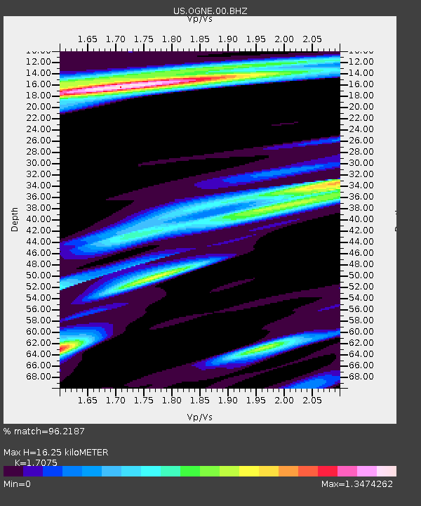
| Estimated Moho Depth: |
16.25 km |
| Estimated Crust Vp/Vs: |
1.71 |
| Assumed Crust Vp: |
6.483 km/s |
| Estimated Crust Vs: |
3.797 km/s |
| Estimated Crust Poisson's Ratio: |
0.24 |
|
| Radial Match: |
96.2187 % |
| Radial Bump: |
325 |
| Transverse Match: |
91.332306 % |
| Transverse Bump: |
400 |
| SOD ConfigId: |
1475611 |
| Insert Time: |
2016-06-01 08:17:49.521 +0000 |
| GWidth: |
2.5 |
| Max Bumps: |
400 |
| Tol: |
0.001 |
|
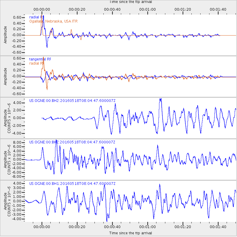
Signal To Noise
| Channel | StoN | STA | LTA |
| US:OGNE:00:BHZ:20160518T08:04:47.600007Z | 37.09816 | 2.9853072E-6 | 8.047049E-8 |
| US:OGNE:00:BH1:20160518T08:04:47.600007Z | 8.797438 | 1.6928574E-6 | 1.9242619E-7 |
| US:OGNE:00:BH2:20160518T08:04:47.600007Z | 7.846797 | 1.8429213E-6 | 2.3486287E-7 |
| Arrivals |
| Ps | 1.9 SECOND |
| PpPs | 6.3 SECOND |
| PsPs/PpSs | 8.2 SECOND |


