You are here: Home > Network List > US - United States National Seismic Network Stations List
> Station SCIA State Center, Iowa, USA > Earthquake Result Viewer
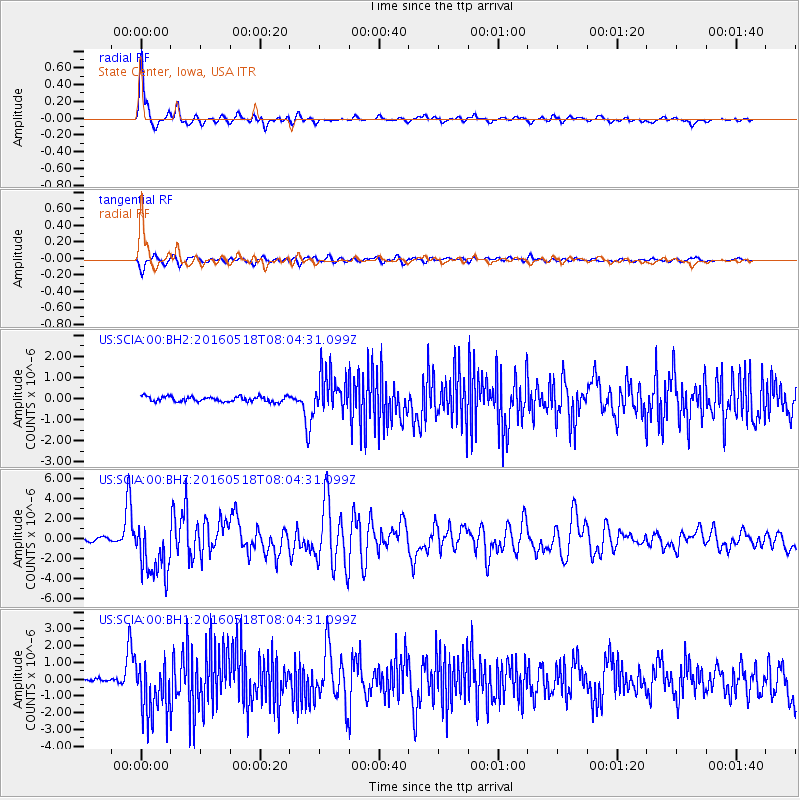
SCIA State Center, Iowa, USA - Earthquake Result Viewer

| Earthquake location: |
Near Coast Of Ecuador |
| Earthquake latitude/longitude: |
0.4/-79.8 |
| Earthquake time(UTC): |
2016/05/18 (139) 07:57:05 GMT |
| Earthquake Depth: |
32 km |
| Earthquake Magnitude: |
6.7 MWP, 6.7 MWW, 6.7 MI |
| Earthquake Catalog/Contributor: |
NEIC PDE/NEIC COMCAT |
|
| Network: |
US United States National Seismic Network |
| Station: |
SCIA State Center, Iowa, USA |
| Lat/Lon: |
41.91 N/93.22 W |
| Elevation: |
312 m |
|
| Distance: |
43.0 deg |
| Az: |
345.262 deg |
| Baz: |
160.074 deg |
| Ray Param: |
0.072743766 |
| Estimated Moho Depth: |
42.75 km |
| Estimated Crust Vp/Vs: |
1.66 |
| Assumed Crust Vp: |
6.498 km/s |
| Estimated Crust Vs: |
3.908 km/s |
| Estimated Crust Poisson's Ratio: |
0.22 |
|
| Radial Match: |
91.736 % |
| Radial Bump: |
372 |
| Transverse Match: |
81.09628 % |
| Transverse Bump: |
400 |
| SOD ConfigId: |
1475611 |
| Insert Time: |
2016-06-01 08:18:06.327 +0000 |
| GWidth: |
2.5 |
| Max Bumps: |
400 |
| Tol: |
0.001 |
|
Signal To Noise
| Channel | StoN | STA | LTA |
| US:SCIA:00:BHZ:20160518T08:04:31.099Z | 18.15664 | 2.8252905E-6 | 1.5560647E-7 |
| US:SCIA:00:BH1:20160518T08:04:31.099Z | 12.083897 | 1.7235507E-6 | 1.4263203E-7 |
| US:SCIA:00:BH2:20160518T08:04:31.099Z | 7.538928 | 9.34496E-7 | 1.2395608E-7 |
| Arrivals |
| Ps | 4.7 SECOND |
| PpPs | 16 SECOND |
| PsPs/PpSs | 21 SECOND |


