You are here: Home > Network List > TA - USArray Transportable Network (new EarthScope stations) Stations List
> Station J21A Lysite, WY, USA > Earthquake Result Viewer
J21A Lysite, WY, USA - Earthquake Result Viewer

| Earthquake location: |
Hokkaido, Japan Region |
| Earthquake latitude/longitude: |
41.9/143.8 |
| Earthquake time(UTC): |
2008/09/11 (255) 00:20:50 GMT |
| Earthquake Depth: |
25 km |
| Earthquake Magnitude: |
6.1 MB, 7.0 MS, 6.8 MW, 6.8 MW |
| Earthquake Catalog/Contributor: |
WHDF/NEIC |
|
| Network: |
TA USArray Transportable Network (new EarthScope stations) |
| Station: |
J21A Lysite, WY, USA |
| Lat/Lon: |
43.35 N/107.45 W |
| Elevation: |
1913 m |
|
| Distance: |
73.8 deg |
| Az: |
45.993 deg |
| Baz: |
312.598 deg |
| Ray Param: |
0.05275079 |
| Estimated Moho Depth: |
43.5 km |
| Estimated Crust Vp/Vs: |
1.60 |
| Assumed Crust Vp: |
6.178 km/s |
| Estimated Crust Vs: |
3.861 km/s |
| Estimated Crust Poisson's Ratio: |
0.18 |
|
| Radial Match: |
82.3169 % |
| Radial Bump: |
400 |
| Transverse Match: |
75.436584 % |
| Transverse Bump: |
400 |
| SOD ConfigId: |
2560 |
| Insert Time: |
2010-03-06 11:07:54.434 +0000 |
| GWidth: |
2.5 |
| Max Bumps: |
400 |
| Tol: |
0.001 |
|
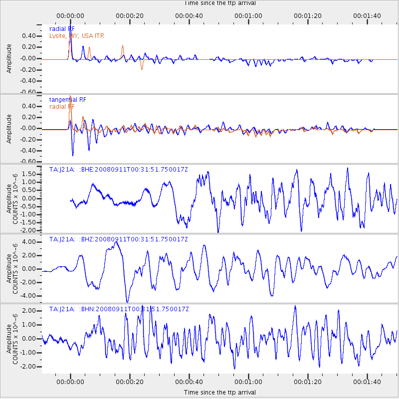
Signal To Noise
| Channel | StoN | STA | LTA |
| TA:J21A: :BHZ:20080911T00:31:51.750017Z | 2.895004 | 1.1443624E-6 | 3.9528868E-7 |
| TA:J21A: :BHN:20080911T00:31:51.750017Z | 1.5231805 | 5.563552E-7 | 3.6525884E-7 |
| TA:J21A: :BHE:20080911T00:31:51.750017Z | 2.1387453 | 7.4610665E-7 | 3.488525E-7 |
| Arrivals |
| Ps | 4.4 SECOND |
| PpPs | 18 SECOND |
| PsPs/PpSs | 22 SECOND |


