You are here: Home > Network List > TA - USArray Transportable Network (new EarthScope stations) Stations List
> Station J21A Lysite, WY, USA > Earthquake Result Viewer
J21A Lysite, WY, USA - Earthquake Result Viewer
| Earthquake location: |
Samoa Islands Region |
| Earthquake latitude/longitude: |
-15.8/-172.6 |
| Earthquake time(UTC): |
2009/09/29 (272) 23:45:03 GMT |
| Earthquake Depth: |
10 km |
| Earthquake Magnitude: |
6.0 MB, 5.8 MS |
| Earthquake Catalog/Contributor: |
WHDF/NEIC |
|
| Network: |
TA USArray Transportable Network (new EarthScope stations) |
| Station: |
J21A Lysite, WY, USA |
| Lat/Lon: |
43.35 N/107.45 W |
| Elevation: |
1913 m |
|
| Distance: |
83.7 deg |
| Az: |
41.743 deg |
| Baz: |
241.456 deg |
| Ray Param: |
0.04601884 |
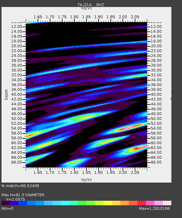
| Estimated Moho Depth: |
61.0 km |
| Estimated Crust Vp/Vs: |
2.09 |
| Assumed Crust Vp: |
6.178 km/s |
| Estimated Crust Vs: |
2.96 km/s |
| Estimated Crust Poisson's Ratio: |
0.35 |
|
| Radial Match: |
88.53489 % |
| Radial Bump: |
359 |
| Transverse Match: |
63.987125 % |
| Transverse Bump: |
400 |
| SOD ConfigId: |
2622 |
| Insert Time: |
2010-03-06 11:08:03.086 +0000 |
| GWidth: |
2.5 |
| Max Bumps: |
400 |
| Tol: |
0.001 |
|
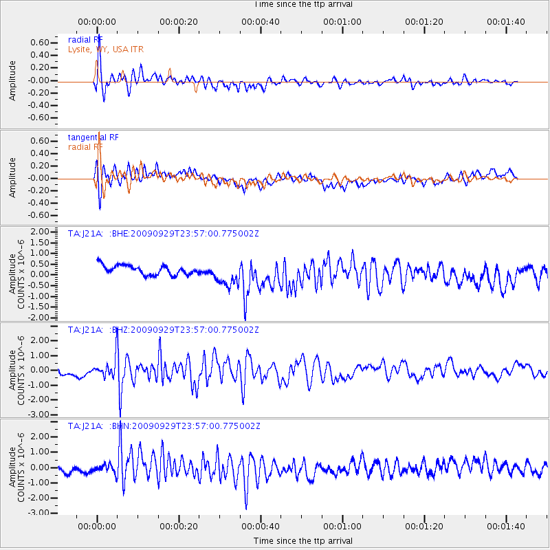
Signal To Noise
| Channel | StoN | STA | LTA |
| TA:J21A: :BHZ:20090929T23:57:00.775002Z | 2.8773615 | 6.4007503E-7 | 2.2245206E-7 |
| TA:J21A: :BHN:20090929T23:57:00.775002Z | 1.647171 | 3.3487547E-7 | 2.0330339E-7 |
| TA:J21A: :BHE:20090929T23:57:00.775002Z | 2.7942247 | 6.1691554E-7 | 2.2078235E-7 |
| Arrivals |
| Ps | 11 SECOND |
| PpPs | 30 SECOND |
| PsPs/PpSs | 41 SECOND |


