You are here: Home > Network List > CI - Caltech Regional Seismic Network Stations List
> Station SMM Simmler, CA, USA > Earthquake Result Viewer
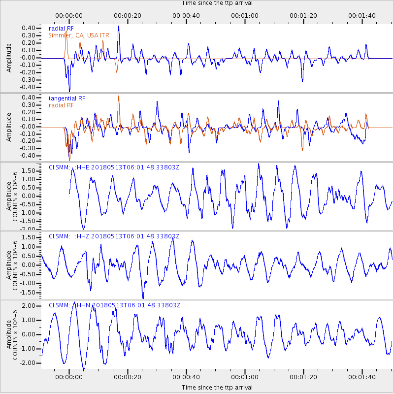
SMM Simmler, CA, USA - Earthquake Result Viewer
*The percent match for this event was below the threshold and hence no stack was calculated.
| Earthquake location: |
Tonga Islands |
| Earthquake latitude/longitude: |
-21.2/-173.9 |
| Earthquake time(UTC): |
2018/05/13 (133) 05:50:33 GMT |
| Earthquake Depth: |
10 km |
| Earthquake Magnitude: |
5.6 mb |
| Earthquake Catalog/Contributor: |
NEIC PDE/us |
|
| Network: |
CI Caltech Regional Seismic Network |
| Station: |
SMM Simmler, CA, USA |
| Lat/Lon: |
35.31 N/120.00 W |
| Elevation: |
599 m |
|
| Distance: |
75.9 deg |
| Az: |
42.929 deg |
| Baz: |
231.016 deg |
| Ray Param: |
$rayparam |
*The percent match for this event was below the threshold and hence was not used in the summary stack. |
|
| Radial Match: |
58.239098 % |
| Radial Bump: |
400 |
| Transverse Match: |
22.598864 % |
| Transverse Bump: |
255 |
| SOD ConfigId: |
13570011 |
| Insert Time: |
2019-04-30 06:04:58.853 +0000 |
| GWidth: |
2.5 |
| Max Bumps: |
400 |
| Tol: |
0.001 |
|
Signal To Noise
| Channel | StoN | STA | LTA |
| CI:SMM: :HHZ:20180513T06:01:48.33803Z | 1.3862679 | 3.8899174E-7 | 2.806036E-7 |
| CI:SMM: :HHN:20180513T06:01:48.33803Z | 1.5117128 | 1.5304428E-6 | 1.0123899E-6 |
| CI:SMM: :HHE:20180513T06:01:48.33803Z | 0.70549333 | 5.8908705E-7 | 8.350002E-7 |
| Arrivals |
| Ps | |
| PpPs | |
| PsPs/PpSs | |


