You are here: Home > Network List > TA - USArray Transportable Network (new EarthScope stations) Stations List
> Station J21A Lysite, WY, USA > Earthquake Result Viewer
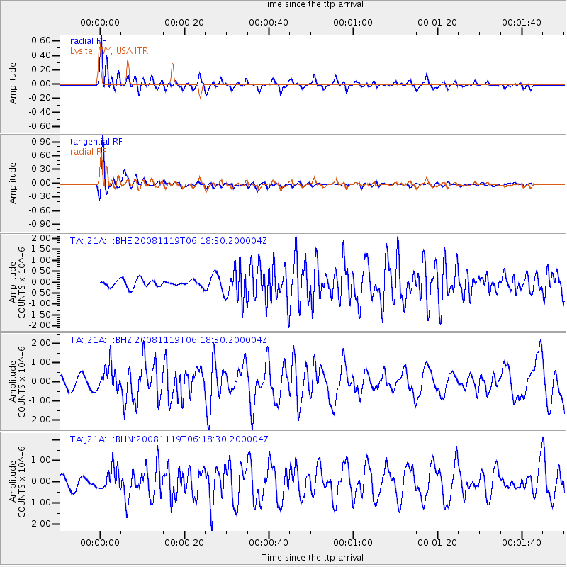
J21A Lysite, WY, USA - Earthquake Result Viewer
*The percent match for this event was below the threshold and hence no stack was calculated.
| Earthquake location: |
Panama-Costa Rica Border Region |
| Earthquake latitude/longitude: |
8.3/-83.0 |
| Earthquake time(UTC): |
2008/11/19 (324) 06:11:20 GMT |
| Earthquake Depth: |
32 km |
| Earthquake Magnitude: |
5.9 MB, 5.9 MS, 6.2 MW, 6.1 MW |
| Earthquake Catalog/Contributor: |
WHDF/NEIC |
|
| Network: |
TA USArray Transportable Network (new EarthScope stations) |
| Station: |
J21A Lysite, WY, USA |
| Lat/Lon: |
43.35 N/107.45 W |
| Elevation: |
1913 m |
|
| Distance: |
41.0 deg |
| Az: |
332.558 deg |
| Baz: |
141.3 deg |
| Ray Param: |
$rayparam |
*The percent match for this event was below the threshold and hence was not used in the summary stack. |
|
| Radial Match: |
68.044044 % |
| Radial Bump: |
400 |
| Transverse Match: |
85.66789 % |
| Transverse Bump: |
400 |
| SOD ConfigId: |
2658 |
| Insert Time: |
2010-03-06 11:08:46.052 +0000 |
| GWidth: |
2.5 |
| Max Bumps: |
400 |
| Tol: |
0.001 |
|
Signal To Noise
| Channel | StoN | STA | LTA |
| TA:J21A: :BHZ:20081119T06:18:30.200004Z | 2.1321099 | 6.3299626E-7 | 2.9688726E-7 |
| TA:J21A: :BHN:20081119T06:18:30.200004Z | 1.1521076 | 5.0425194E-7 | 4.3767784E-7 |
| TA:J21A: :BHE:20081119T06:18:30.200004Z | 4.3106685 | 6.857846E-7 | 1.5909008E-7 |
| Arrivals |
| Ps | |
| PpPs | |
| PsPs/PpSs | |


