You are here: Home > Network List > TA - USArray Transportable Network (new EarthScope stations) Stations List
> Station J21A Lysite, WY, USA > Earthquake Result Viewer
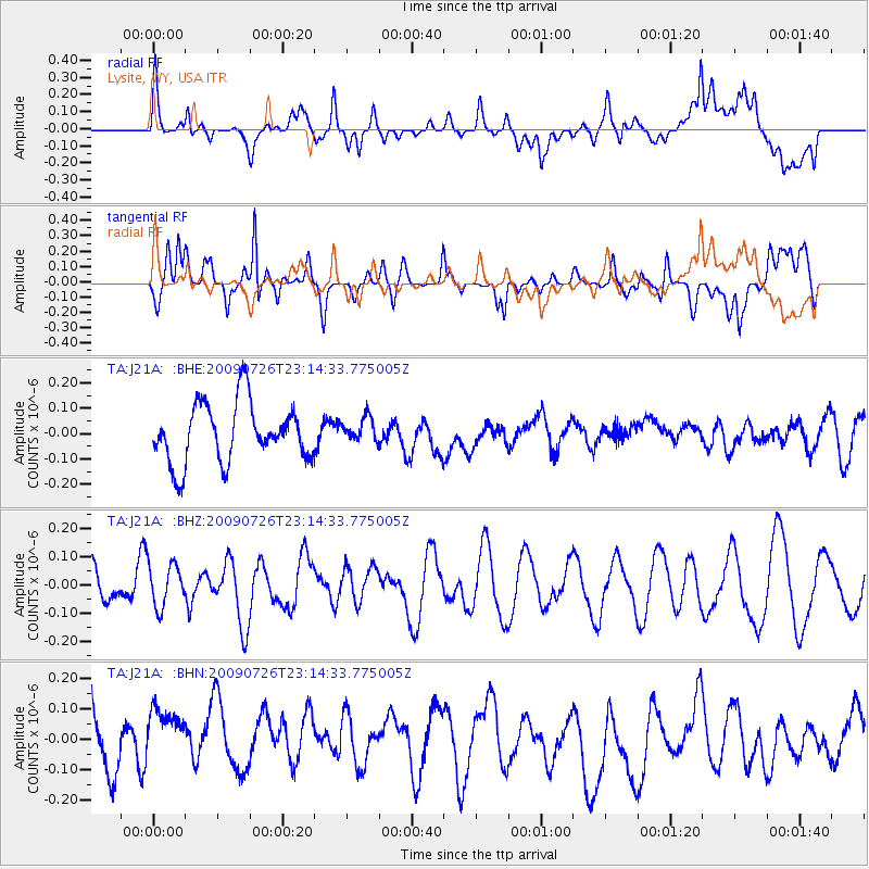
J21A Lysite, WY, USA - Earthquake Result Viewer
*The percent match for this event was below the threshold and hence no stack was calculated.
| Earthquake location: |
Vanuatu Islands |
| Earthquake latitude/longitude: |
-17.8/168.1 |
| Earthquake time(UTC): |
2009/07/26 (207) 23:01:31 GMT |
| Earthquake Depth: |
25 km |
| Earthquake Magnitude: |
5.8 MB, 5.9 MW, 5.7 MW |
| Earthquake Catalog/Contributor: |
WHDF/NEIC |
|
| Network: |
TA USArray Transportable Network (new EarthScope stations) |
| Station: |
J21A Lysite, WY, USA |
| Lat/Lon: |
43.35 N/107.45 W |
| Elevation: |
1913 m |
|
| Distance: |
98.1 deg |
| Az: |
47.169 deg |
| Baz: |
253.333 deg |
| Ray Param: |
$rayparam |
*The percent match for this event was below the threshold and hence was not used in the summary stack. |
|
| Radial Match: |
53.225246 % |
| Radial Bump: |
400 |
| Transverse Match: |
45.881657 % |
| Transverse Bump: |
377 |
| SOD ConfigId: |
2622 |
| Insert Time: |
2010-03-06 11:08:47.655 +0000 |
| GWidth: |
2.5 |
| Max Bumps: |
400 |
| Tol: |
0.001 |
|
Signal To Noise
| Channel | StoN | STA | LTA |
| TA:J21A: :BHZ:20090726T23:14:33.775005Z | 0.997538 | 7.4436876E-8 | 7.4620594E-8 |
| TA:J21A: :BHN:20090726T23:14:33.775005Z | 0.98797107 | 1.6203194E-7 | 1.6400473E-7 |
| TA:J21A: :BHE:20090726T23:14:33.775005Z | 0.41804403 | 4.853608E-8 | 1.1610279E-7 |
| Arrivals |
| Ps | |
| PpPs | |
| PsPs/PpSs | |


