You are here: Home > Network List > UU - University of Utah Regional Network Stations List
> Station CTU Camp Tracy, UT, USA > Earthquake Result Viewer
CTU Camp Tracy, UT, USA - Earthquake Result Viewer
| Earthquake location: |
Near Coast Of Ecuador |
| Earthquake latitude/longitude: |
0.4/-79.8 |
| Earthquake time(UTC): |
2016/05/18 (139) 07:57:05 GMT |
| Earthquake Depth: |
32 km |
| Earthquake Magnitude: |
6.7 MWP, 6.7 MWW, 6.7 MI |
| Earthquake Catalog/Contributor: |
NEIC PDE/NEIC COMCAT |
|
| Network: |
UU University of Utah Regional Network |
| Station: |
CTU Camp Tracy, UT, USA |
| Lat/Lon: |
40.69 N/111.75 W |
| Elevation: |
1731 m |
|
| Distance: |
49.5 deg |
| Az: |
328.004 deg |
| Baz: |
135.828 deg |
| Ray Param: |
0.0686146 |
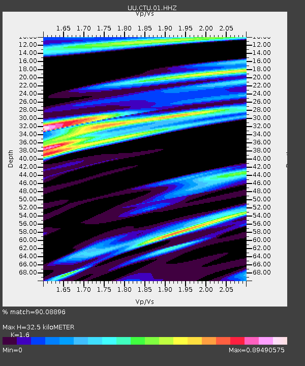
| Estimated Moho Depth: |
32.5 km |
| Estimated Crust Vp/Vs: |
1.60 |
| Assumed Crust Vp: |
6.155 km/s |
| Estimated Crust Vs: |
3.847 km/s |
| Estimated Crust Poisson's Ratio: |
0.18 |
|
| Radial Match: |
90.08896 % |
| Radial Bump: |
400 |
| Transverse Match: |
85.536194 % |
| Transverse Bump: |
400 |
| SOD ConfigId: |
1475611 |
| Insert Time: |
2016-06-01 08:19:04.448 +0000 |
| GWidth: |
2.5 |
| Max Bumps: |
400 |
| Tol: |
0.001 |
|

Signal To Noise
| Channel | StoN | STA | LTA |
| UU:CTU:01:HHZ:20160518T08:05:21.600007Z | 9.38071 | 2.341241E-8 | 2.4958036E-9 |
| UU:CTU:01:HHN:20160518T08:05:21.600007Z | 3.2512522 | 8.213272E-9 | 2.526187E-9 |
| UU:CTU:01:HHE:20160518T08:05:21.600007Z | 2.9676144 | 6.4754007E-9 | 2.1820223E-9 |
| Arrivals |
| Ps | 3.4 SECOND |
| PpPs | 13 SECOND |
| PsPs/PpSs | 16 SECOND |


