You are here: Home > Network List > UU - University of Utah Regional Network Stations List
> Station LCMT Little Creek Mountain, UT, USA > Earthquake Result Viewer
LCMT Little Creek Mountain, UT, USA - Earthquake Result Viewer
| Earthquake location: |
Near Coast Of Ecuador |
| Earthquake latitude/longitude: |
0.4/-79.8 |
| Earthquake time(UTC): |
2016/05/18 (139) 07:57:05 GMT |
| Earthquake Depth: |
32 km |
| Earthquake Magnitude: |
6.7 MWP, 6.7 MWW, 6.7 MI |
| Earthquake Catalog/Contributor: |
NEIC PDE/NEIC COMCAT |
|
| Network: |
UU University of Utah Regional Network |
| Station: |
LCMT Little Creek Mountain, UT, USA |
| Lat/Lon: |
37.01 N/113.24 W |
| Elevation: |
1411 m |
|
| Distance: |
47.8 deg |
| Az: |
323.394 deg |
| Baz: |
131.846 deg |
| Ray Param: |
0.069717236 |
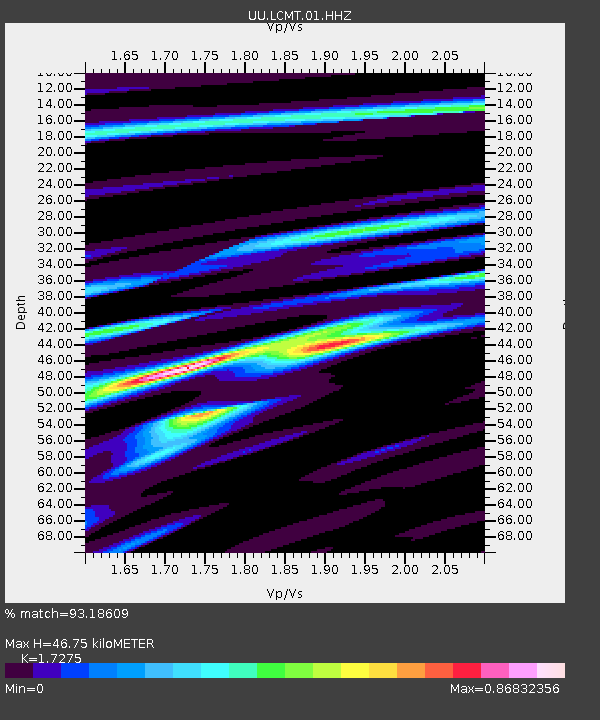
| Estimated Moho Depth: |
46.75 km |
| Estimated Crust Vp/Vs: |
1.73 |
| Assumed Crust Vp: |
6.194 km/s |
| Estimated Crust Vs: |
3.586 km/s |
| Estimated Crust Poisson's Ratio: |
0.25 |
|
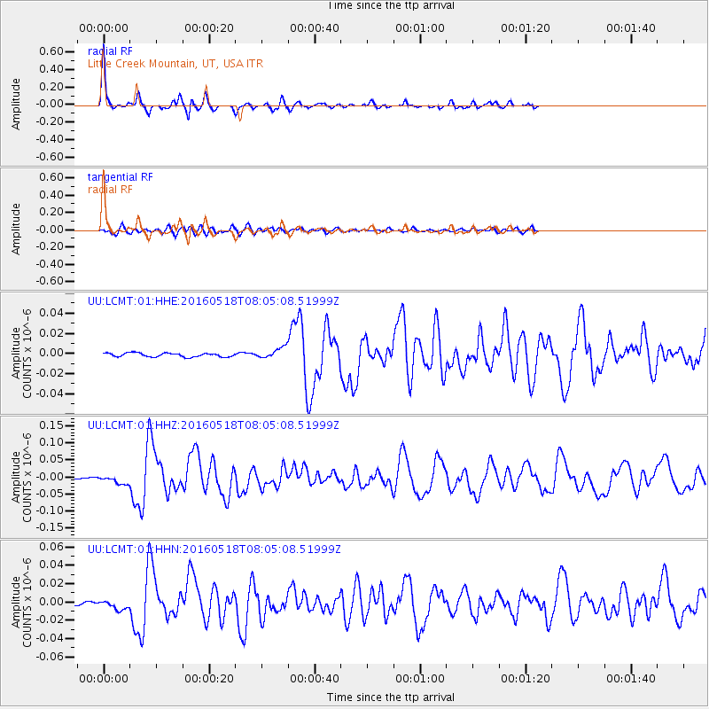
| Radial Match: |
93.18609 % |
| Radial Bump: |
266 |
| Transverse Match: |
70.96705 % |
| Transverse Bump: |
400 |
| SOD ConfigId: |
1475611 |
| Insert Time: |
2016-06-01 08:19:37.527 +0000 |
| GWidth: |
2.5 |
| Max Bumps: |
400 |
| Tol: |
0.001 |
|
Signal To Noise
| Channel | StoN | STA | LTA |
| UU:LCMT:01:HHZ:20160518T08:05:08.51999Z | 4.915992 | 1.2028704E-8 | 2.4468518E-9 |
| UU:LCMT:01:HHN:20160518T08:05:08.51999Z | 3.3900719 | 5.180489E-9 | 1.5281354E-9 |
| UU:LCMT:01:HHE:20160518T08:05:08.51999Z | 2.804279 | 5.248001E-9 | 1.871426E-9 |
| Arrivals |
| Ps | 5.8 SECOND |
| PpPs | 19 SECOND |
| PsPs/PpSs | 25 SECOND |


