You are here: Home > Network List > TA - USArray Transportable Network (new EarthScope stations) Stations List
> Station J21A Lysite, WY, USA > Earthquake Result Viewer
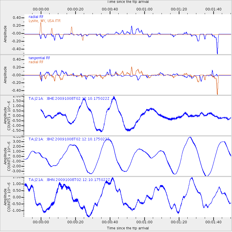
J21A Lysite, WY, USA - Earthquake Result Viewer
*The percent match for this event was below the threshold and hence no stack was calculated.
| Earthquake location: |
Santa Cruz Islands |
| Earthquake latitude/longitude: |
-11.9/166.0 |
| Earthquake time(UTC): |
2009/10/08 (281) 01:59:19 GMT |
| Earthquake Depth: |
35 km |
| Earthquake Magnitude: |
5.9 MB |
| Earthquake Catalog/Contributor: |
WHDF/NEIC |
|
| Network: |
TA USArray Transportable Network (new EarthScope stations) |
| Station: |
J21A Lysite, WY, USA |
| Lat/Lon: |
43.35 N/107.45 W |
| Elevation: |
1913 m |
|
| Distance: |
95.6 deg |
| Az: |
47.032 deg |
| Baz: |
259.04 deg |
| Ray Param: |
$rayparam |
*The percent match for this event was below the threshold and hence was not used in the summary stack. |
|
| Radial Match: |
67.841866 % |
| Radial Bump: |
400 |
| Transverse Match: |
76.79144 % |
| Transverse Bump: |
400 |
| SOD ConfigId: |
2622 |
| Insert Time: |
2010-03-06 11:09:22.894 +0000 |
| GWidth: |
2.5 |
| Max Bumps: |
400 |
| Tol: |
0.001 |
|
Signal To Noise
| Channel | StoN | STA | LTA |
| TA:J21A: :BHZ:20091008T02:12:10.175022Z | 0.6760054 | 6.1186995E-7 | 9.051258E-7 |
| TA:J21A: :BHN:20091008T02:12:10.175022Z | 1.8732487 | 1.2890623E-6 | 6.881426E-7 |
| TA:J21A: :BHE:20091008T02:12:10.175022Z | 2.2192907 | 1.1997001E-6 | 5.405782E-7 |
| Arrivals |
| Ps | |
| PpPs | |
| PsPs/PpSs | |


