You are here: Home > Network List > TA - USArray Transportable Network (new EarthScope stations) Stations List
> Station J21A Lysite, WY, USA > Earthquake Result Viewer
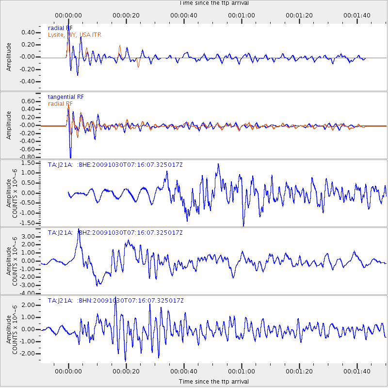
J21A Lysite, WY, USA - Earthquake Result Viewer
*The percent match for this event was below the threshold and hence no stack was calculated.
| Earthquake location: |
Ryukyu Islands, Japan |
| Earthquake latitude/longitude: |
29.2/129.8 |
| Earthquake time(UTC): |
2009/10/30 (303) 07:03:39 GMT |
| Earthquake Depth: |
34 km |
| Earthquake Magnitude: |
6.3 MB, 6.8 MS, 6.8 MW, 6.8 MW |
| Earthquake Catalog/Contributor: |
WHDF/NEIC |
|
| Network: |
TA USArray Transportable Network (new EarthScope stations) |
| Station: |
J21A Lysite, WY, USA |
| Lat/Lon: |
43.35 N/107.45 W |
| Elevation: |
1913 m |
|
| Distance: |
90.7 deg |
| Az: |
37.84 deg |
| Baz: |
312.686 deg |
| Ray Param: |
$rayparam |
*The percent match for this event was below the threshold and hence was not used in the summary stack. |
|
| Radial Match: |
90.42682 % |
| Radial Bump: |
400 |
| Transverse Match: |
87.988205 % |
| Transverse Bump: |
400 |
| SOD ConfigId: |
2622 |
| Insert Time: |
2010-03-06 11:09:32.773 +0000 |
| GWidth: |
2.5 |
| Max Bumps: |
400 |
| Tol: |
0.001 |
|
Signal To Noise
| Channel | StoN | STA | LTA |
| TA:J21A: :BHZ:20091030T07:16:07.325017Z | 10.264564 | 1.6635189E-6 | 1.6206427E-7 |
| TA:J21A: :BHN:20091030T07:16:07.325017Z | 3.8016028 | 4.6703062E-7 | 1.2285096E-7 |
| TA:J21A: :BHE:20091030T07:16:07.325017Z | 2.8418825 | 4.986034E-7 | 1.7544828E-7 |
| Arrivals |
| Ps | |
| PpPs | |
| PsPs/PpSs | |


