You are here: Home > Network List > TA - USArray Transportable Network (new EarthScope stations) Stations List
> Station J21A Lysite, WY, USA > Earthquake Result Viewer
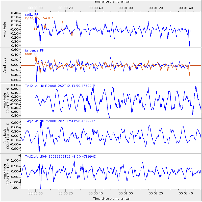
J21A Lysite, WY, USA - Earthquake Result Viewer
*The percent match for this event was below the threshold and hence no stack was calculated.
| Earthquake location: |
Mariana Islands |
| Earthquake latitude/longitude: |
19.1/145.8 |
| Earthquake time(UTC): |
2008/12/02 (337) 12:31:43 GMT |
| Earthquake Depth: |
137 km |
| Earthquake Magnitude: |
5.9 MB, 5.9 MW, 5.9 MW |
| Earthquake Catalog/Contributor: |
WHDF/NEIC |
|
| Network: |
TA USArray Transportable Network (new EarthScope stations) |
| Station: |
J21A Lysite, WY, USA |
| Lat/Lon: |
43.35 N/107.45 W |
| Elevation: |
1913 m |
|
| Distance: |
88.7 deg |
| Az: |
44.311 deg |
| Baz: |
295.117 deg |
| Ray Param: |
$rayparam |
*The percent match for this event was below the threshold and hence was not used in the summary stack. |
|
| Radial Match: |
58.85661 % |
| Radial Bump: |
379 |
| Transverse Match: |
58.866352 % |
| Transverse Bump: |
400 |
| SOD ConfigId: |
2658 |
| Insert Time: |
2010-03-06 11:09:48.017 +0000 |
| GWidth: |
2.5 |
| Max Bumps: |
400 |
| Tol: |
0.001 |
|
Signal To Noise
| Channel | StoN | STA | LTA |
| TA:J21A: :BHZ:20081202T12:43:50.473994Z | 2.737224 | 5.542168E-7 | 2.0247404E-7 |
| TA:J21A: :BHN:20081202T12:43:50.473994Z | 2.4106836 | 5.770146E-7 | 2.3935726E-7 |
| TA:J21A: :BHE:20081202T12:43:50.473994Z | 1.0037663 | 2.8744404E-7 | 2.863655E-7 |
| Arrivals |
| Ps | |
| PpPs | |
| PsPs/PpSs | |


