You are here: Home > Network List > TA - USArray Transportable Network (new EarthScope stations) Stations List
> Station J21A Lysite, WY, USA > Earthquake Result Viewer
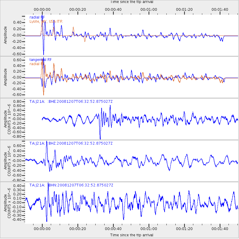
J21A Lysite, WY, USA - Earthquake Result Viewer
*The percent match for this event was below the threshold and hence no stack was calculated.
| Earthquake location: |
Northern Mid-Atlantic Ridge |
| Earthquake latitude/longitude: |
13.4/-44.8 |
| Earthquake time(UTC): |
2008/12/07 (342) 06:23:09 GMT |
| Earthquake Depth: |
10 km |
| Earthquake Magnitude: |
5.6 MB, 5.3 MS, 5.7 MW |
| Earthquake Catalog/Contributor: |
WHDF/NEIC |
|
| Network: |
TA USArray Transportable Network (new EarthScope stations) |
| Station: |
J21A Lysite, WY, USA |
| Lat/Lon: |
43.35 N/107.45 W |
| Elevation: |
1913 m |
|
| Distance: |
61.1 deg |
| Az: |
312.266 deg |
| Baz: |
99.122 deg |
| Ray Param: |
$rayparam |
*The percent match for this event was below the threshold and hence was not used in the summary stack. |
|
| Radial Match: |
55.105 % |
| Radial Bump: |
400 |
| Transverse Match: |
62.311356 % |
| Transverse Bump: |
400 |
| SOD ConfigId: |
2658 |
| Insert Time: |
2010-03-06 11:09:51.270 +0000 |
| GWidth: |
2.5 |
| Max Bumps: |
400 |
| Tol: |
0.001 |
|
Signal To Noise
| Channel | StoN | STA | LTA |
| TA:J21A: :BHZ:20081207T06:32:52.875027Z | 2.7229214 | 2.7421214E-7 | 1.0070512E-7 |
| TA:J21A: :BHN:20081207T06:32:52.875027Z | 2.2408671 | 1.9428765E-7 | 8.6701995E-8 |
| TA:J21A: :BHE:20081207T06:32:52.875027Z | 2.9462292 | 3.238795E-7 | 1.09930184E-7 |
| Arrivals |
| Ps | |
| PpPs | |
| PsPs/PpSs | |


