You are here: Home > Network List > TJ - Tajikistan National Seismic Network Stations List
> Station CHGR Chuyangaron, Tajikistan > Earthquake Result Viewer
CHGR Chuyangaron, Tajikistan - Earthquake Result Viewer
| Earthquake location: |
Northwest Of Madagascar |
| Earthquake latitude/longitude: |
-12.8/45.6 |
| Earthquake time(UTC): |
2018/05/15 (135) 15:48:08 GMT |
| Earthquake Depth: |
10 km |
| Earthquake Magnitude: |
5.9 Mww |
| Earthquake Catalog/Contributor: |
NEIC PDE/us |
|
| Network: |
TJ Tajikistan National Seismic Network |
| Station: |
CHGR Chuyangaron, Tajikistan |
| Lat/Lon: |
38.66 N/69.16 E |
| Elevation: |
1049 m |
|
| Distance: |
55.7 deg |
| Az: |
22.271 deg |
| Baz: |
208.179 deg |
| Ray Param: |
0.0646181 |
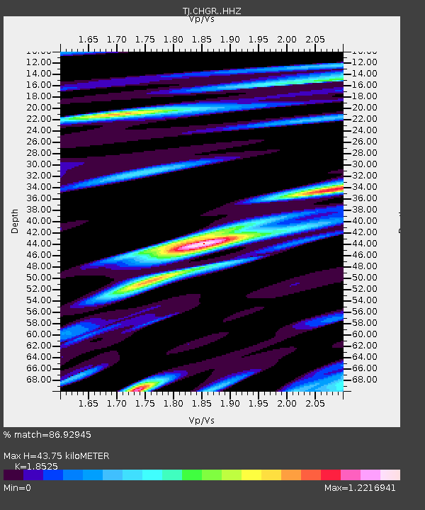
| Estimated Moho Depth: |
43.75 km |
| Estimated Crust Vp/Vs: |
1.85 |
| Assumed Crust Vp: |
6.483 km/s |
| Estimated Crust Vs: |
3.499 km/s |
| Estimated Crust Poisson's Ratio: |
0.29 |
|
| Radial Match: |
86.92945 % |
| Radial Bump: |
400 |
| Transverse Match: |
82.30004 % |
| Transverse Bump: |
400 |
| SOD ConfigId: |
13570011 |
| Insert Time: |
2019-04-30 06:16:15.260 +0000 |
| GWidth: |
2.5 |
| Max Bumps: |
400 |
| Tol: |
0.001 |
|

Signal To Noise
| Channel | StoN | STA | LTA |
| TJ:CHGR: :HHZ:20180515T15:57:14.420027Z | 6.8642197 | 6.966695E-7 | 1.0149289E-7 |
| TJ:CHGR: :HHN:20180515T15:57:14.420027Z | 5.3130903 | 3.4724746E-7 | 6.5356964E-8 |
| TJ:CHGR: :HHE:20180515T15:57:14.420027Z | 3.0465403 | 1.843126E-7 | 6.049899E-8 |
| Arrivals |
| Ps | 6.1 SECOND |
| PpPs | 18 SECOND |
| PsPs/PpSs | 24 SECOND |


