You are here: Home > Network List > TJ - Tajikistan National Seismic Network Stations List
> Station GARM Garm, Tajikistan > Earthquake Result Viewer
GARM Garm, Tajikistan - Earthquake Result Viewer
| Earthquake location: |
Northwest Of Madagascar |
| Earthquake latitude/longitude: |
-12.8/45.6 |
| Earthquake time(UTC): |
2018/05/15 (135) 15:48:08 GMT |
| Earthquake Depth: |
10 km |
| Earthquake Magnitude: |
5.9 Mww |
| Earthquake Catalog/Contributor: |
NEIC PDE/us |
|
| Network: |
TJ Tajikistan National Seismic Network |
| Station: |
GARM Garm, Tajikistan |
| Lat/Lon: |
39.00 N/70.32 E |
| Elevation: |
1305 m |
|
| Distance: |
56.4 deg |
| Az: |
23.027 deg |
| Baz: |
209.324 deg |
| Ray Param: |
0.064139225 |
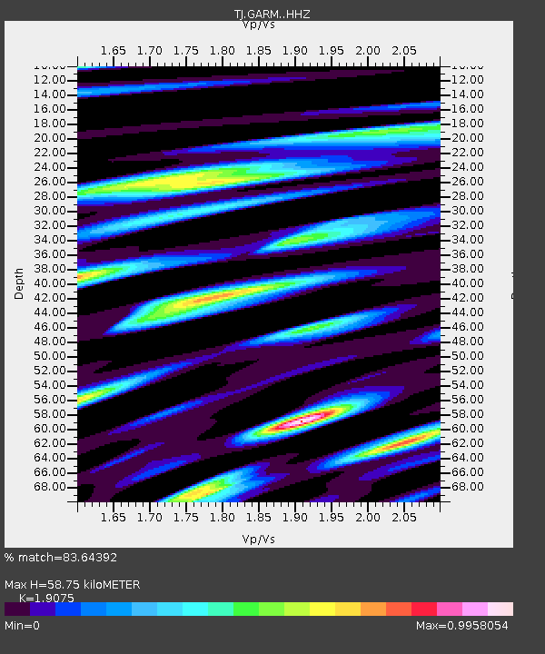
| Estimated Moho Depth: |
58.75 km |
| Estimated Crust Vp/Vs: |
1.91 |
| Assumed Crust Vp: |
6.306 km/s |
| Estimated Crust Vs: |
3.306 km/s |
| Estimated Crust Poisson's Ratio: |
0.31 |
|
| Radial Match: |
83.64392 % |
| Radial Bump: |
400 |
| Transverse Match: |
72.40784 % |
| Transverse Bump: |
400 |
| SOD ConfigId: |
13570011 |
| Insert Time: |
2019-04-30 06:16:15.394 +0000 |
| GWidth: |
2.5 |
| Max Bumps: |
400 |
| Tol: |
0.001 |
|

Signal To Noise
| Channel | StoN | STA | LTA |
| TJ:GARM: :HHZ:20180515T15:57:19.670027Z | 7.327324 | 4.493535E-7 | 6.1325736E-8 |
| TJ:GARM: :HHN:20180515T15:57:19.670027Z | 3.9553125 | 2.1827866E-7 | 5.51862E-8 |
| TJ:GARM: :HHE:20180515T15:57:19.670027Z | 0.97268575 | 8.9535305E-8 | 9.2049575E-8 |
| Arrivals |
| Ps | 8.8 SECOND |
| PpPs | 26 SECOND |
| PsPs/PpSs | 35 SECOND |


