You are here: Home > Network List > UU - University of Utah Regional Network Stations List
> Station SZCU Shurtz Canyon, UT, USA > Earthquake Result Viewer
SZCU Shurtz Canyon, UT, USA - Earthquake Result Viewer
| Earthquake location: |
Near Coast Of Ecuador |
| Earthquake latitude/longitude: |
0.4/-79.8 |
| Earthquake time(UTC): |
2016/05/18 (139) 07:57:05 GMT |
| Earthquake Depth: |
32 km |
| Earthquake Magnitude: |
6.7 MWP, 6.7 MWW, 6.7 MI |
| Earthquake Catalog/Contributor: |
NEIC PDE/NEIC COMCAT |
|
| Network: |
UU University of Utah Regional Network |
| Station: |
SZCU Shurtz Canyon, UT, USA |
| Lat/Lon: |
37.60 N/113.09 W |
| Elevation: |
2026 m |
|
| Distance: |
48.1 deg |
| Az: |
324.089 deg |
| Baz: |
132.406 deg |
| Ray Param: |
0.069531895 |
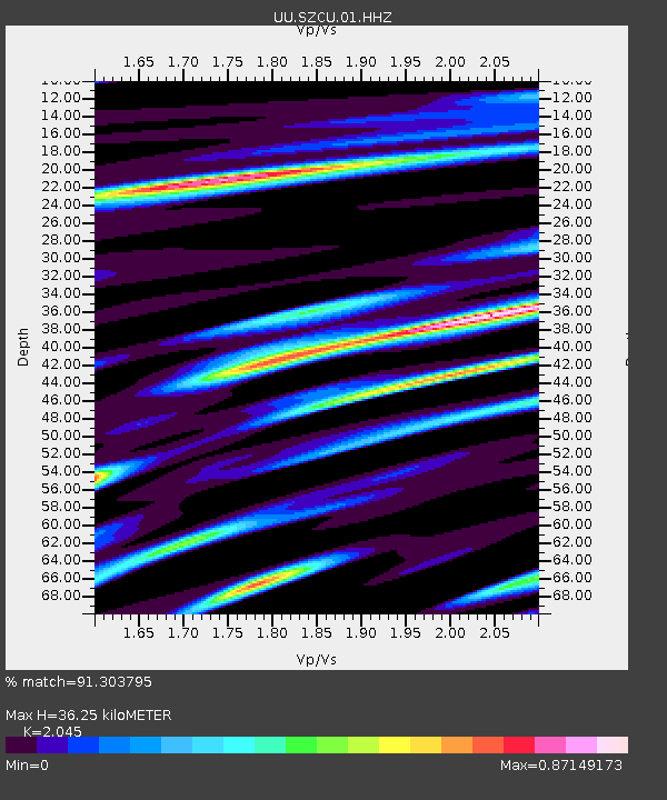
| Estimated Moho Depth: |
36.25 km |
| Estimated Crust Vp/Vs: |
2.05 |
| Assumed Crust Vp: |
6.194 km/s |
| Estimated Crust Vs: |
3.029 km/s |
| Estimated Crust Poisson's Ratio: |
0.34 |
|
| Radial Match: |
91.303795 % |
| Radial Bump: |
356 |
| Transverse Match: |
81.30838 % |
| Transverse Bump: |
400 |
| SOD ConfigId: |
1475611 |
| Insert Time: |
2016-06-01 08:20:55.961 +0000 |
| GWidth: |
2.5 |
| Max Bumps: |
400 |
| Tol: |
0.001 |
|

Signal To Noise
| Channel | StoN | STA | LTA |
| UU:SZCU:01:HHZ:20160518T08:05:10.820009Z | 3.9801319 | 1.19637695E-8 | 3.0058727E-9 |
| UU:SZCU:01:HHN:20160518T08:05:10.820009Z | 1.6053479 | 3.099943E-9 | 1.93101E-9 |
| UU:SZCU:01:HHE:20160518T08:05:10.820009Z | 1.3563964 | 3.3498955E-9 | 2.4697024E-9 |
| Arrivals |
| Ps | 6.4 SECOND |
| PpPs | 17 SECOND |
| PsPs/PpSs | 23 SECOND |


