You are here: Home > Network List > TA - USArray Transportable Network (new EarthScope stations) Stations List
> Station J21A Lysite, WY, USA > Earthquake Result Viewer
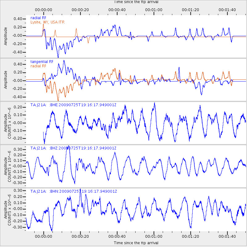
J21A Lysite, WY, USA - Earthquake Result Viewer
*The percent match for this event was below the threshold and hence no stack was calculated.
| Earthquake location: |
Kermadec Islands, New Zealand |
| Earthquake latitude/longitude: |
-29.8/-177.7 |
| Earthquake time(UTC): |
2009/07/25 (206) 19:03:20 GMT |
| Earthquake Depth: |
35 km |
| Earthquake Magnitude: |
5.5 MB, 5.2 MS, 5.6 MW, 5.6 MW |
| Earthquake Catalog/Contributor: |
WHDF/NEIC |
|
| Network: |
TA USArray Transportable Network (new EarthScope stations) |
| Station: |
J21A Lysite, WY, USA |
| Lat/Lon: |
43.35 N/107.45 W |
| Elevation: |
1913 m |
|
| Distance: |
97.1 deg |
| Az: |
43.78 deg |
| Baz: |
235.546 deg |
| Ray Param: |
$rayparam |
*The percent match for this event was below the threshold and hence was not used in the summary stack. |
|
| Radial Match: |
47.149906 % |
| Radial Bump: |
400 |
| Transverse Match: |
39.83481 % |
| Transverse Bump: |
400 |
| SOD ConfigId: |
2648 |
| Insert Time: |
2010-03-06 11:10:10.150 +0000 |
| GWidth: |
2.5 |
| Max Bumps: |
400 |
| Tol: |
0.001 |
|
Signal To Noise
| Channel | StoN | STA | LTA |
| TA:J21A: :BHZ:20090725T19:16:17.949001Z | 0.5281918 | 8.389761E-8 | 1.5883928E-7 |
| TA:J21A: :BHN:20090725T19:16:17.949001Z | 1.0835378 | 2.4955102E-7 | 2.3031131E-7 |
| TA:J21A: :BHE:20090725T19:16:17.949001Z | 0.73347193 | 6.740928E-8 | 9.1904376E-8 |
| Arrivals |
| Ps | |
| PpPs | |
| PsPs/PpSs | |


