You are here: Home > Network List > TA - USArray Transportable Network (new EarthScope stations) Stations List
> Station J21A Lysite, WY, USA > Earthquake Result Viewer
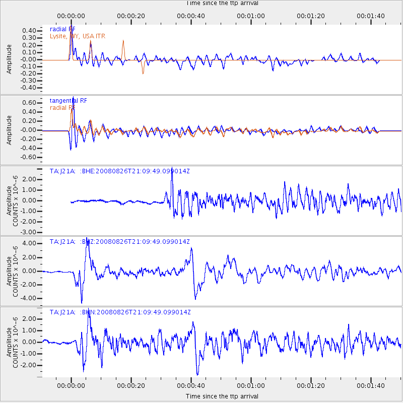
J21A Lysite, WY, USA - Earthquake Result Viewer
*The percent match for this event was below the threshold and hence no stack was calculated.
| Earthquake location: |
Peru-Brazil Border Region |
| Earthquake latitude/longitude: |
-7.6/-74.4 |
| Earthquake time(UTC): |
2008/08/26 (239) 21:00:36 GMT |
| Earthquake Depth: |
154 km |
| Earthquake Magnitude: |
6.0 MB, 6.4 MW, 6.4 MW |
| Earthquake Catalog/Contributor: |
WHDF/NEIC |
|
| Network: |
TA USArray Transportable Network (new EarthScope stations) |
| Station: |
J21A Lysite, WY, USA |
| Lat/Lon: |
43.35 N/107.45 W |
| Elevation: |
1913 m |
|
| Distance: |
59.0 deg |
| Az: |
332.316 deg |
| Baz: |
140.857 deg |
| Ray Param: |
$rayparam |
*The percent match for this event was below the threshold and hence was not used in the summary stack. |
|
| Radial Match: |
89.09641 % |
| Radial Bump: |
400 |
| Transverse Match: |
88.63206 % |
| Transverse Bump: |
400 |
| SOD ConfigId: |
2504 |
| Insert Time: |
2010-03-06 11:10:28.177 +0000 |
| GWidth: |
2.5 |
| Max Bumps: |
400 |
| Tol: |
0.001 |
|
Signal To Noise
| Channel | StoN | STA | LTA |
| TA:J21A: :BHZ:20080826T21:09:49.099014Z | 29.638302 | 1.645757E-6 | 5.5528048E-8 |
| TA:J21A: :BHN:20080826T21:09:49.099014Z | 4.581685 | 8.2408104E-7 | 1.7986419E-7 |
| TA:J21A: :BHE:20080826T21:09:49.099014Z | 11.354667 | 9.72162E-7 | 8.5617835E-8 |
| Arrivals |
| Ps | |
| PpPs | |
| PsPs/PpSs | |


