You are here: Home > Network List > TA - USArray Transportable Network (new EarthScope stations) Stations List
> Station D22K Ayikyak River, AK, USA > Earthquake Result Viewer
D22K Ayikyak River, AK, USA - Earthquake Result Viewer
| Earthquake location: |
Irian Jaya, Indonesia |
| Earthquake latitude/longitude: |
-3.8/138.6 |
| Earthquake time(UTC): |
2018/05/16 (136) 02:12:17 GMT |
| Earthquake Depth: |
88 km |
| Earthquake Magnitude: |
5.4 Mww |
| Earthquake Catalog/Contributor: |
NEIC PDE/us |
|
| Network: |
TA USArray Transportable Network (new EarthScope stations) |
| Station: |
D22K Ayikyak River, AK, USA |
| Lat/Lon: |
68.88 N/152.68 W |
| Elevation: |
532 m |
|
| Distance: |
86.0 deg |
| Az: |
19.788 deg |
| Baz: |
248.76 deg |
| Ray Param: |
0.044195388 |
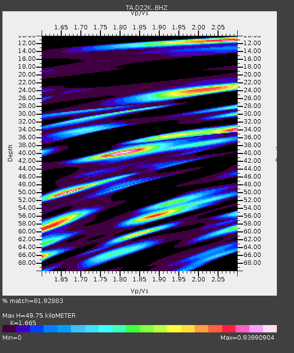
| Estimated Moho Depth: |
49.75 km |
| Estimated Crust Vp/Vs: |
1.66 |
| Assumed Crust Vp: |
6.221 km/s |
| Estimated Crust Vs: |
3.736 km/s |
| Estimated Crust Poisson's Ratio: |
0.22 |
|
| Radial Match: |
81.92883 % |
| Radial Bump: |
400 |
| Transverse Match: |
85.341606 % |
| Transverse Bump: |
400 |
| SOD ConfigId: |
13570011 |
| Insert Time: |
2019-04-30 06:20:17.879 +0000 |
| GWidth: |
2.5 |
| Max Bumps: |
400 |
| Tol: |
0.001 |
|

Signal To Noise
| Channel | StoN | STA | LTA |
| TA:D22K: :BHZ:20180516T02:24:16.625015Z | 11.924162 | 1.010742E-6 | 8.4764196E-8 |
| TA:D22K: :BHN:20180516T02:24:16.625015Z | 3.029182 | 1.4875748E-7 | 4.9108134E-8 |
| TA:D22K: :BHE:20180516T02:24:16.625015Z | 6.865256 | 3.217225E-7 | 4.6862418E-8 |
| Arrivals |
| Ps | 5.4 SECOND |
| PpPs | 21 SECOND |
| PsPs/PpSs | 26 SECOND |


