You are here: Home > Network List > TA - USArray Transportable Network (new EarthScope stations) Stations List
> Station G23K Bananza Creek, AK, USA > Earthquake Result Viewer
G23K Bananza Creek, AK, USA - Earthquake Result Viewer
| Earthquake location: |
Irian Jaya, Indonesia |
| Earthquake latitude/longitude: |
-3.8/138.6 |
| Earthquake time(UTC): |
2018/05/16 (136) 02:12:17 GMT |
| Earthquake Depth: |
88 km |
| Earthquake Magnitude: |
5.4 Mww |
| Earthquake Catalog/Contributor: |
NEIC PDE/us |
|
| Network: |
TA USArray Transportable Network (new EarthScope stations) |
| Station: |
G23K Bananza Creek, AK, USA |
| Lat/Lon: |
66.71 N/150.02 W |
| Elevation: |
746 m |
|
| Distance: |
86.2 deg |
| Az: |
22.187 deg |
| Baz: |
251.382 deg |
| Ray Param: |
0.04404908 |
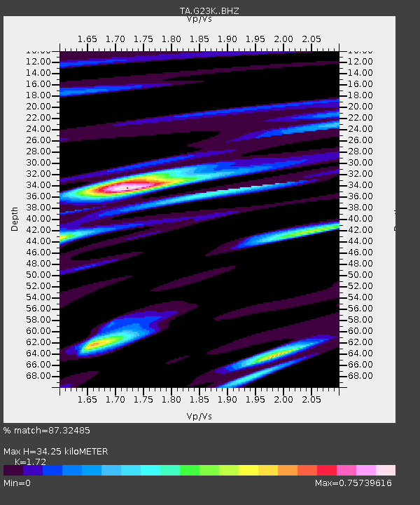
| Estimated Moho Depth: |
34.25 km |
| Estimated Crust Vp/Vs: |
1.72 |
| Assumed Crust Vp: |
6.577 km/s |
| Estimated Crust Vs: |
3.824 km/s |
| Estimated Crust Poisson's Ratio: |
0.24 |
|
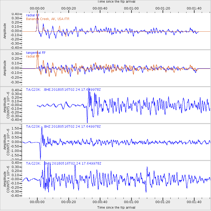
| Radial Match: |
87.32485 % |
| Radial Bump: |
400 |
| Transverse Match: |
71.35031 % |
| Transverse Bump: |
400 |
| SOD ConfigId: |
13570011 |
| Insert Time: |
2019-04-30 06:20:43.338 +0000 |
| GWidth: |
2.5 |
| Max Bumps: |
400 |
| Tol: |
0.001 |
|
Signal To Noise
| Channel | StoN | STA | LTA |
| TA:G23K: :BHZ:20180516T02:24:17.649978Z | 21.678055 | 6.868474E-7 | 3.1683996E-8 |
| TA:G23K: :BHN:20180516T02:24:17.649978Z | 3.67575 | 1.1996178E-7 | 3.2636002E-8 |
| TA:G23K: :BHE:20180516T02:24:17.649978Z | 5.6579127 | 1.908238E-7 | 3.3726888E-8 |
| Arrivals |
| Ps | 3.8 SECOND |
| PpPs | 14 SECOND |
| PsPs/PpSs | 18 SECOND |


