You are here: Home > Network List > TA - USArray Transportable Network (new EarthScope stations) Stations List
> Station J20A Shoshoni, WY, USA > Earthquake Result Viewer
J20A Shoshoni, WY, USA - Earthquake Result Viewer

| Earthquake location: |
Tonga Islands |
| Earthquake latitude/longitude: |
-21.9/-173.8 |
| Earthquake time(UTC): |
2008/10/19 (293) 05:10:33 GMT |
| Earthquake Depth: |
29 km |
| Earthquake Magnitude: |
6.8 MB, 7.0 MS, 6.9 MW, 6.9 MW |
| Earthquake Catalog/Contributor: |
WHDF/NEIC |
|
| Network: |
TA USArray Transportable Network (new EarthScope stations) |
| Station: |
J20A Shoshoni, WY, USA |
| Lat/Lon: |
43.35 N/108.08 W |
| Elevation: |
1500 m |
|
| Distance: |
88.6 deg |
| Az: |
41.698 deg |
| Baz: |
237.902 deg |
| Ray Param: |
0.042464435 |
| Estimated Moho Depth: |
64.0 km |
| Estimated Crust Vp/Vs: |
1.84 |
| Assumed Crust Vp: |
6.161 km/s |
| Estimated Crust Vs: |
3.357 km/s |
| Estimated Crust Poisson's Ratio: |
0.29 |
|
| Radial Match: |
88.74422 % |
| Radial Bump: |
400 |
| Transverse Match: |
80.23189 % |
| Transverse Bump: |
400 |
| SOD ConfigId: |
2556 |
| Insert Time: |
2010-03-06 11:11:04.863 +0000 |
| GWidth: |
2.5 |
| Max Bumps: |
400 |
| Tol: |
0.001 |
|
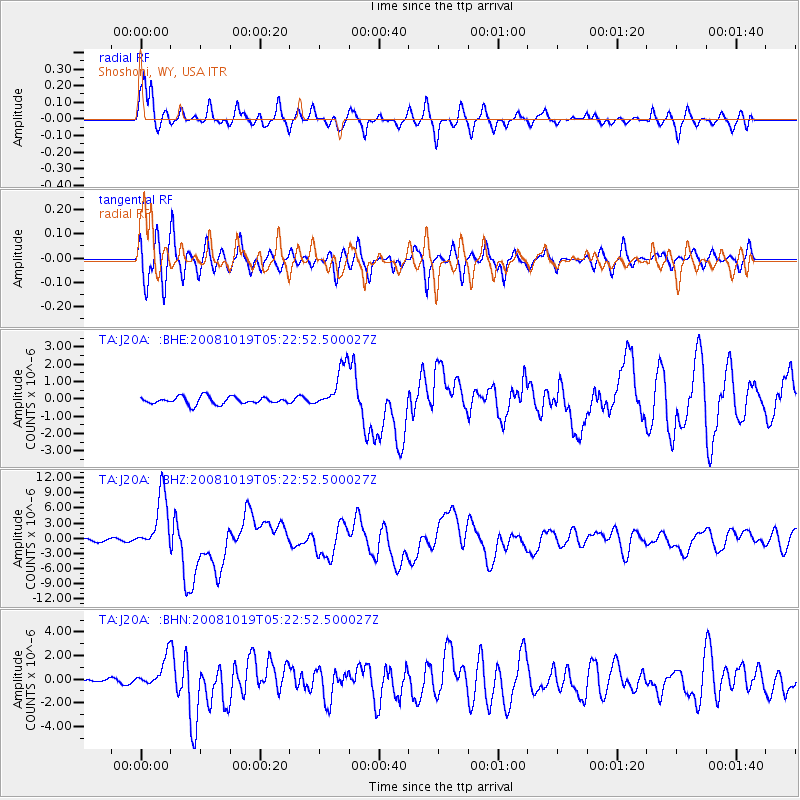
Signal To Noise
| Channel | StoN | STA | LTA |
| TA:J20A: :BHZ:20081019T05:22:52.500027Z | 25.492802 | 5.6370777E-6 | 2.2112428E-7 |
| TA:J20A: :BHN:20081019T05:22:52.500027Z | 6.2381554 | 1.235802E-6 | 1.9810375E-7 |
| TA:J20A: :BHE:20081019T05:22:52.500027Z | 6.1242185 | 1.2795182E-6 | 2.0892759E-7 |
| Arrivals |
| Ps | 8.8 SECOND |
| PpPs | 29 SECOND |
| PsPs/PpSs | 38 SECOND |


