You are here: Home > Network List > TA - USArray Transportable Network (new EarthScope stations) Stations List
> Station I28M Miner Creek, YT, CAN > Earthquake Result Viewer
I28M Miner Creek, YT, CAN - Earthquake Result Viewer
| Earthquake location: |
Irian Jaya, Indonesia |
| Earthquake latitude/longitude: |
-3.8/138.6 |
| Earthquake time(UTC): |
2018/05/16 (136) 02:12:17 GMT |
| Earthquake Depth: |
88 km |
| Earthquake Magnitude: |
5.4 Mww |
| Earthquake Catalog/Contributor: |
NEIC PDE/us |
|
| Network: |
TA USArray Transportable Network (new EarthScope stations) |
| Station: |
I28M Miner Creek, YT, CAN |
| Lat/Lon: |
65.45 N/139.94 W |
| Elevation: |
1188 m |
|
| Distance: |
89.9 deg |
| Az: |
24.406 deg |
| Baz: |
260.675 deg |
| Ray Param: |
0.04169675 |
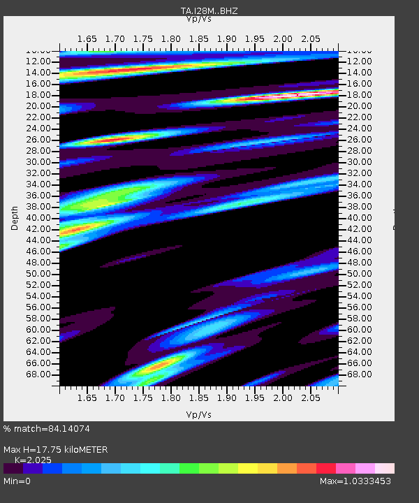
| Estimated Moho Depth: |
17.75 km |
| Estimated Crust Vp/Vs: |
2.03 |
| Assumed Crust Vp: |
6.566 km/s |
| Estimated Crust Vs: |
3.243 km/s |
| Estimated Crust Poisson's Ratio: |
0.34 |
|
| Radial Match: |
84.14074 % |
| Radial Bump: |
400 |
| Transverse Match: |
63.240852 % |
| Transverse Bump: |
400 |
| SOD ConfigId: |
13570011 |
| Insert Time: |
2019-04-30 06:21:04.342 +0000 |
| GWidth: |
2.5 |
| Max Bumps: |
400 |
| Tol: |
0.001 |
|

Signal To Noise
| Channel | StoN | STA | LTA |
| TA:I28M: :BHZ:20180516T02:24:35.09999Z | 10.397188 | 6.028874E-7 | 5.798562E-8 |
| TA:I28M: :BHN:20180516T02:24:35.09999Z | 1.8880564 | 1.280389E-7 | 6.781519E-8 |
| TA:I28M: :BHE:20180516T02:24:35.09999Z | 6.423715 | 2.1042378E-7 | 3.2757335E-8 |
| Arrivals |
| Ps | 2.8 SECOND |
| PpPs | 8.0 SECOND |
| PsPs/PpSs | 11 SECOND |


