You are here: Home > Network List > TA - USArray Transportable Network (new EarthScope stations) Stations List
> Station J20A Shoshoni, WY, USA > Earthquake Result Viewer
J20A Shoshoni, WY, USA - Earthquake Result Viewer

| Earthquake location: |
Off Coast Of Costa Rica |
| Earthquake latitude/longitude: |
7.9/-85.6 |
| Earthquake time(UTC): |
2009/08/13 (225) 09:37:35 GMT |
| Earthquake Depth: |
10 km |
| Earthquake Magnitude: |
5.8 MW, 5.3 MB |
| Earthquake Catalog/Contributor: |
WHDF/NEIC |
|
| Network: |
TA USArray Transportable Network (new EarthScope stations) |
| Station: |
J20A Shoshoni, WY, USA |
| Lat/Lon: |
43.35 N/108.08 W |
| Elevation: |
1500 m |
|
| Distance: |
40.4 deg |
| Az: |
334.535 deg |
| Baz: |
144.279 deg |
| Ray Param: |
0.07443185 |
| Estimated Moho Depth: |
16.75 km |
| Estimated Crust Vp/Vs: |
1.66 |
| Assumed Crust Vp: |
6.161 km/s |
| Estimated Crust Vs: |
3.711 km/s |
| Estimated Crust Poisson's Ratio: |
0.22 |
|
| Radial Match: |
88.26479 % |
| Radial Bump: |
400 |
| Transverse Match: |
74.49469 % |
| Transverse Bump: |
400 |
| SOD ConfigId: |
2622 |
| Insert Time: |
2010-03-06 11:11:18.500 +0000 |
| GWidth: |
2.5 |
| Max Bumps: |
400 |
| Tol: |
0.001 |
|
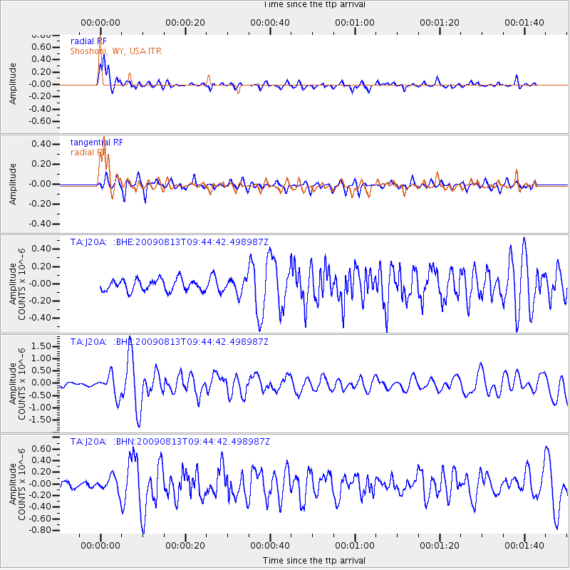
Signal To Noise
| Channel | StoN | STA | LTA |
| TA:J20A: :BHZ:20090813T09:44:42.498987Z | 5.2647586 | 4.4859078E-7 | 8.520633E-8 |
| TA:J20A: :BHN:20090813T09:44:42.498987Z | 1.6122913 | 1.3740532E-7 | 8.522363E-8 |
| TA:J20A: :BHE:20090813T09:44:42.498987Z | 1.3232795 | 8.5900034E-8 | 6.49145E-8 |
| Arrivals |
| Ps | 1.9 SECOND |
| PpPs | 6.8 SECOND |
| PsPs/PpSs | 8.7 SECOND |


