You are here: Home > Network List > TA - USArray Transportable Network (new EarthScope stations) Stations List
> Station J20A Shoshoni, WY, USA > Earthquake Result Viewer
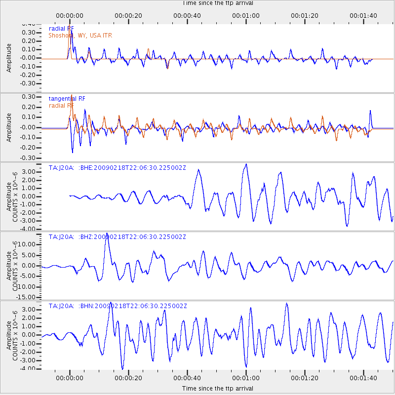
J20A Shoshoni, WY, USA - Earthquake Result Viewer
| Earthquake location: |
Kermadec Islands Region |
| Earthquake latitude/longitude: |
-27.4/-176.3 |
| Earthquake time(UTC): |
2009/02/18 (049) 21:53:45 GMT |
| Earthquake Depth: |
25 km |
| Earthquake Magnitude: |
6.8 MB, 7.2 MS, 6.9 MW, 6.9 MW |
| Earthquake Catalog/Contributor: |
WHDF/NEIC |
|
| Network: |
TA USArray Transportable Network (new EarthScope stations) |
| Station: |
J20A Shoshoni, WY, USA |
| Lat/Lon: |
43.35 N/108.08 W |
| Elevation: |
1500 m |
|
| Distance: |
94.2 deg |
| Az: |
42.789 deg |
| Baz: |
235.872 deg |
| Ray Param: |
0.041093174 |
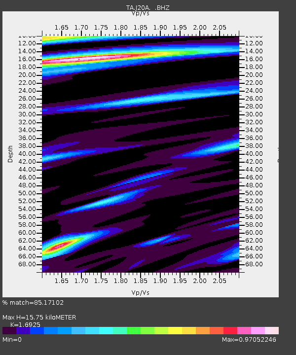
| Estimated Moho Depth: |
15.75 km |
| Estimated Crust Vp/Vs: |
1.69 |
| Assumed Crust Vp: |
6.161 km/s |
| Estimated Crust Vs: |
3.64 km/s |
| Estimated Crust Poisson's Ratio: |
0.23 |
|
| Radial Match: |
85.17102 % |
| Radial Bump: |
368 |
| Transverse Match: |
80.62881 % |
| Transverse Bump: |
400 |
| SOD ConfigId: |
2658 |
| Insert Time: |
2010-03-06 11:11:33.702 +0000 |
| GWidth: |
2.5 |
| Max Bumps: |
400 |
| Tol: |
0.001 |
|
Signal To Noise
| Channel | StoN | STA | LTA |
| TA:J20A: :BHZ:20090218T22:06:30.225002Z | 4.743638 | 1.3733423E-6 | 2.8951246E-7 |
| TA:J20A: :BHN:20090218T22:06:30.225002Z | 3.7104971 | 5.953621E-7 | 1.6045345E-7 |
| TA:J20A: :BHE:20090218T22:06:30.225002Z | 1.2614001 | 3.944289E-7 | 3.1269136E-7 |
| Arrivals |
| Ps | 1.8 SECOND |
| PpPs | 6.8 SECOND |
| PsPs/PpSs | 8.6 SECOND |


