You are here: Home > Network List > TA - USArray Transportable Network (new EarthScope stations) Stations List
> Station P17K Kvichak River, AK, USA > Earthquake Result Viewer
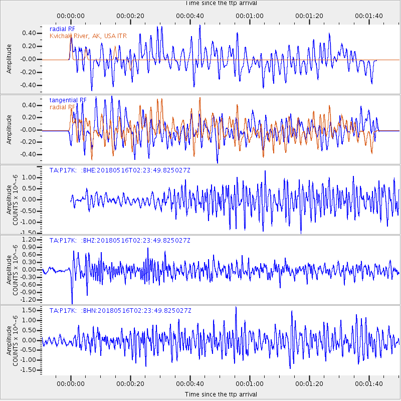
P17K Kvichak River, AK, USA - Earthquake Result Viewer
*The percent match for this event was below the threshold and hence no stack was calculated.
| Earthquake location: |
Irian Jaya, Indonesia |
| Earthquake latitude/longitude: |
-3.8/138.6 |
| Earthquake time(UTC): |
2018/05/16 (136) 02:12:17 GMT |
| Earthquake Depth: |
88 km |
| Earthquake Magnitude: |
5.4 Mww |
| Earthquake Catalog/Contributor: |
NEIC PDE/us |
|
| Network: |
TA USArray Transportable Network (new EarthScope stations) |
| Station: |
P17K Kvichak River, AK, USA |
| Lat/Lon: |
59.20 N/156.44 W |
| Elevation: |
91 m |
|
| Distance: |
80.7 deg |
| Az: |
28.193 deg |
| Baz: |
246.348 deg |
| Ray Param: |
$rayparam |
*The percent match for this event was below the threshold and hence was not used in the summary stack. |
|
| Radial Match: |
58.096413 % |
| Radial Bump: |
400 |
| Transverse Match: |
60.51212 % |
| Transverse Bump: |
400 |
| SOD ConfigId: |
13570011 |
| Insert Time: |
2019-04-30 06:21:57.484 +0000 |
| GWidth: |
2.5 |
| Max Bumps: |
400 |
| Tol: |
0.001 |
|
Signal To Noise
| Channel | StoN | STA | LTA |
| TA:P17K: :BHZ:20180516T02:23:49.825027Z | 6.639851 | 4.2405895E-7 | 6.3865734E-8 |
| TA:P17K: :BHN:20180516T02:23:49.825027Z | 1.7432289 | 2.696853E-7 | 1.5470447E-7 |
| TA:P17K: :BHE:20180516T02:23:49.825027Z | 1.4271861 | 2.5540228E-7 | 1.7895513E-7 |
| Arrivals |
| Ps | |
| PpPs | |
| PsPs/PpSs | |


