You are here: Home > Network List > TA - USArray Transportable Network (new EarthScope stations) Stations List
> Station J20A Shoshoni, WY, USA > Earthquake Result Viewer
J20A Shoshoni, WY, USA - Earthquake Result Viewer
| Earthquake location: |
Kuril Islands |
| Earthquake latitude/longitude: |
46.0/151.4 |
| Earthquake time(UTC): |
2009/04/18 (108) 19:17:58 GMT |
| Earthquake Depth: |
35 km |
| Earthquake Magnitude: |
6.3 MB, 6.3 MS, 6.6 MW, 6.4 MW |
| Earthquake Catalog/Contributor: |
WHDF/NEIC |
|
| Network: |
TA USArray Transportable Network (new EarthScope stations) |
| Station: |
J20A Shoshoni, WY, USA |
| Lat/Lon: |
43.35 N/108.08 W |
| Elevation: |
1500 m |
|
| Distance: |
66.5 deg |
| Az: |
51.431 deg |
| Baz: |
311.672 deg |
| Ray Param: |
0.05748898 |
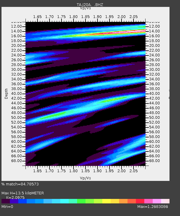
| Estimated Moho Depth: |
13.5 km |
| Estimated Crust Vp/Vs: |
2.10 |
| Assumed Crust Vp: |
6.161 km/s |
| Estimated Crust Vs: |
2.937 km/s |
| Estimated Crust Poisson's Ratio: |
0.35 |
|
| Radial Match: |
84.78573 % |
| Radial Bump: |
400 |
| Transverse Match: |
72.480194 % |
| Transverse Bump: |
400 |
| SOD ConfigId: |
2658 |
| Insert Time: |
2010-03-06 11:11:44.533 +0000 |
| GWidth: |
2.5 |
| Max Bumps: |
400 |
| Tol: |
0.001 |
|

Signal To Noise
| Channel | StoN | STA | LTA |
| TA:J20A: :BHZ:20090418T19:28:14.500007Z | 18.607315 | 1.5442748E-6 | 8.299289E-8 |
| TA:J20A: :BHN:20090418T19:28:14.500007Z | 3.9218116 | 4.7490045E-7 | 1.2109211E-7 |
| TA:J20A: :BHE:20090418T19:28:14.500007Z | 2.0195684 | 3.6881008E-7 | 1.8261827E-7 |
| Arrivals |
| Ps | 2.5 SECOND |
| PpPs | 6.6 SECOND |
| PsPs/PpSs | 9.1 SECOND |


