You are here: Home > Network List > CI - Caltech Regional Seismic Network Stations List
> Station TOV Thousand Oaks, California, USA > Earthquake Result Viewer
TOV Thousand Oaks, California, USA - Earthquake Result Viewer
| Earthquake location: |
South Of Aleutian Islands |
| Earthquake latitude/longitude: |
51.8/-166.3 |
| Earthquake time(UTC): |
2004/08/07 (220) 09:30:16 GMT |
| Earthquake Depth: |
8.0 km |
| Earthquake Magnitude: |
6.3 MB, 5.4 MS, 6.0 MW, 6.0 MW |
| Earthquake Catalog/Contributor: |
WHDF/NEIC |
|
| Network: |
CI Caltech Regional Seismic Network |
| Station: |
TOV Thousand Oaks, California, USA |
| Lat/Lon: |
34.16 N/118.82 W |
| Elevation: |
50 m |
|
| Distance: |
38.2 deg |
| Az: |
98.512 deg |
| Baz: |
312.154 deg |
| Ray Param: |
0.07571559 |
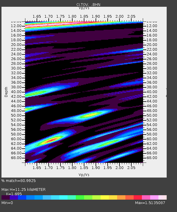
| Estimated Moho Depth: |
11.25 km |
| Estimated Crust Vp/Vs: |
1.70 |
| Assumed Crust Vp: |
6.1 km/s |
| Estimated Crust Vs: |
3.599 km/s |
| Estimated Crust Poisson's Ratio: |
0.23 |
|
| Radial Match: |
80.9925 % |
| Radial Bump: |
400 |
| Transverse Match: |
66.42988 % |
| Transverse Bump: |
400 |
| SOD ConfigId: |
2459 |
| Insert Time: |
2010-02-26 01:57:53.353 +0000 |
| GWidth: |
2.5 |
| Max Bumps: |
400 |
| Tol: |
0.001 |
|

Signal To Noise
| Channel | StoN | STA | LTA |
| CI:TOV: :BHN:20040807T09:37:06.011014Z | 2.7349522 | 6.389812E-7 | 2.3363522E-7 |
| CI:TOV: :BHE:20040807T09:37:06.011014Z | 3.537011 | 6.193972E-7 | 1.7511883E-7 |
| CI:TOV: :BHZ:20040807T09:37:06.011014Z | 9.7101 | 1.7333064E-6 | 1.785055E-7 |
| Arrivals |
| Ps | 1.4 SECOND |
| PpPs | 4.6 SECOND |
| PsPs/PpSs | 6.0 SECOND |


