You are here: Home > Network List > G - GEOSCOPE Stations List
> Station CLF Chambon la Foret observatory, France > Earthquake Result Viewer
CLF Chambon la Foret observatory, France - Earthquake Result Viewer
| Earthquake location: |
Near Coast Of Ecuador |
| Earthquake latitude/longitude: |
0.5/-79.6 |
| Earthquake time(UTC): |
2016/05/18 (139) 16:46:44 GMT |
| Earthquake Depth: |
31 km |
| Earthquake Magnitude: |
6.8 MO |
| Earthquake Catalog/Contributor: |
NEIC PDE/NEIC ALERT |
|
| Network: |
G GEOSCOPE |
| Station: |
CLF Chambon la Foret observatory, France |
| Lat/Lon: |
48.03 N/2.26 E |
| Elevation: |
145 m |
|
| Distance: |
84.2 deg |
| Az: |
41.91 deg |
| Baz: |
264.289 deg |
| Ray Param: |
0.045592174 |
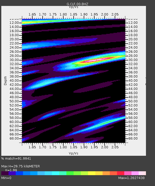
| Estimated Moho Depth: |
29.75 km |
| Estimated Crust Vp/Vs: |
1.96 |
| Assumed Crust Vp: |
6.12 km/s |
| Estimated Crust Vs: |
3.122 km/s |
| Estimated Crust Poisson's Ratio: |
0.32 |
|
| Radial Match: |
91.9941 % |
| Radial Bump: |
400 |
| Transverse Match: |
62.634674 % |
| Transverse Bump: |
395 |
| SOD ConfigId: |
1475611 |
| Insert Time: |
2016-06-01 16:48:34.129 +0000 |
| GWidth: |
2.5 |
| Max Bumps: |
400 |
| Tol: |
0.001 |
|
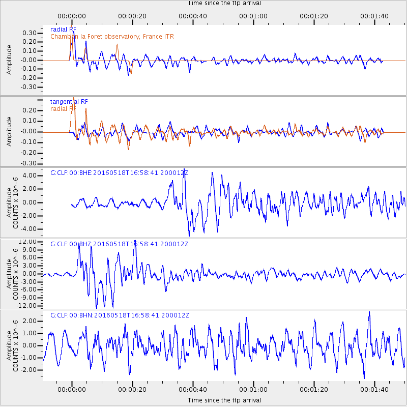
Signal To Noise
| Channel | StoN | STA | LTA |
| G:CLF:00:BHZ:20160518T16:58:41.200012Z | 10.861432 | 4.237717E-6 | 3.9016192E-7 |
| G:CLF:00:BHN:20160518T16:58:41.200012Z | 0.84913856 | 6.9847675E-7 | 8.22571E-7 |
| G:CLF:00:BHE:20160518T16:58:41.200012Z | 3.8489425 | 1.5797544E-6 | 4.1043856E-7 |
| Arrivals |
| Ps | 4.8 SECOND |
| PpPs | 14 SECOND |
| PsPs/PpSs | 19 SECOND |


