You are here: Home > Network List > TA - USArray Transportable Network (new EarthScope stations) Stations List
> Station J20A Shoshoni, WY, USA > Earthquake Result Viewer
J20A Shoshoni, WY, USA - Earthquake Result Viewer

| Earthquake location: |
Off Coast Of Ecuador |
| Earthquake latitude/longitude: |
1.4/-85.2 |
| Earthquake time(UTC): |
2009/05/10 (130) 01:16:06 GMT |
| Earthquake Depth: |
6.0 km |
| Earthquake Magnitude: |
5.5 MB, 5.7 MS, 6.1 MW, 6.1 MW |
| Earthquake Catalog/Contributor: |
WHDF/NEIC |
|
| Network: |
TA USArray Transportable Network (new EarthScope stations) |
| Station: |
J20A Shoshoni, WY, USA |
| Lat/Lon: |
43.35 N/108.08 W |
| Elevation: |
1500 m |
|
| Distance: |
46.5 deg |
| Az: |
336.954 deg |
| Baz: |
147.554 deg |
| Ray Param: |
0.070607826 |
| Estimated Moho Depth: |
10.0 km |
| Estimated Crust Vp/Vs: |
1.75 |
| Assumed Crust Vp: |
6.161 km/s |
| Estimated Crust Vs: |
3.526 km/s |
| Estimated Crust Poisson's Ratio: |
0.26 |
|
| Radial Match: |
86.266754 % |
| Radial Bump: |
400 |
| Transverse Match: |
78.35236 % |
| Transverse Bump: |
400 |
| SOD ConfigId: |
2760 |
| Insert Time: |
2010-03-06 11:12:04.438 +0000 |
| GWidth: |
2.5 |
| Max Bumps: |
400 |
| Tol: |
0.001 |
|
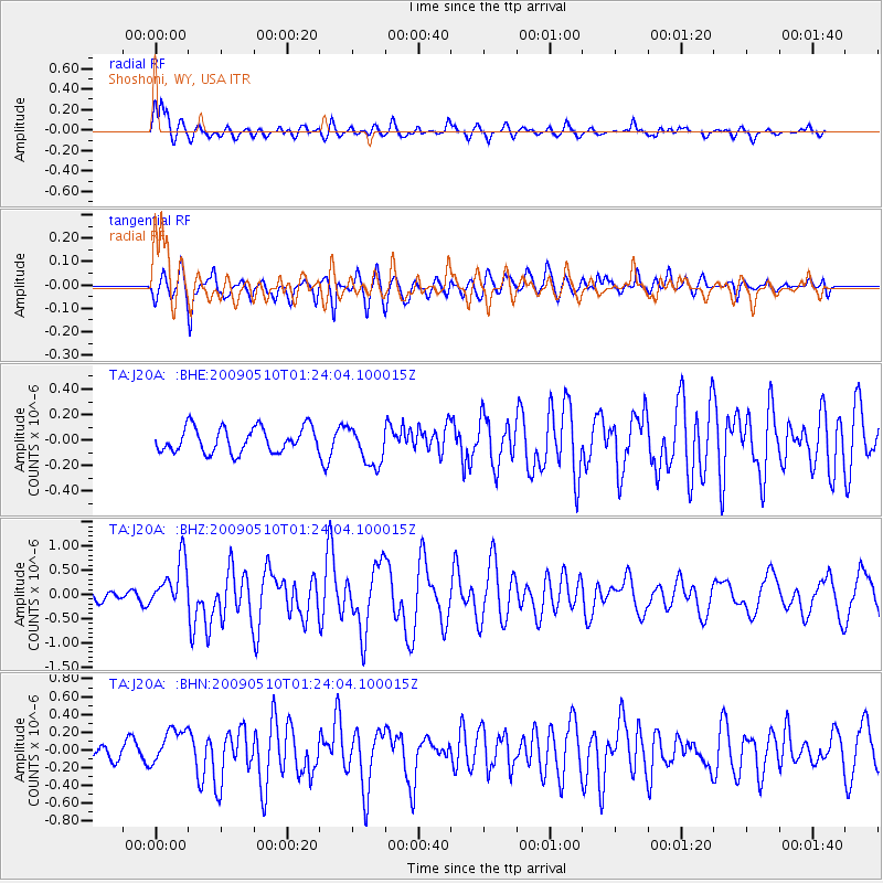
Signal To Noise
| Channel | StoN | STA | LTA |
| TA:J20A: :BHZ:20090510T01:24:04.100015Z | 4.314741 | 5.016604E-7 | 1.1626663E-7 |
| TA:J20A: :BHN:20090510T01:24:04.100015Z | 1.590258 | 2.117154E-7 | 1.3313273E-7 |
| TA:J20A: :BHE:20090510T01:24:04.100015Z | 1.584851 | 1.5494999E-7 | 9.776944E-8 |
| Arrivals |
| Ps | 1.3 SECOND |
| PpPs | 4.2 SECOND |
| PsPs/PpSs | 5.5 SECOND |


