You are here: Home > Network List > TA - USArray Transportable Network (new EarthScope stations) Stations List
> Station J20A Shoshoni, WY, USA > Earthquake Result Viewer
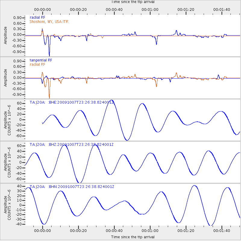
J20A Shoshoni, WY, USA - Earthquake Result Viewer
*The percent match for this event was below the threshold and hence no stack was calculated.
| Earthquake location: |
Vanuatu Islands |
| Earthquake latitude/longitude: |
-13.1/166.5 |
| Earthquake time(UTC): |
2009/10/07 (280) 23:13:48 GMT |
| Earthquake Depth: |
31 km |
| Earthquake Magnitude: |
6.4 MB, 7.2 MS, 7.4 MW, 7.4 MW |
| Earthquake Catalog/Contributor: |
WHDF/NEIC |
|
| Network: |
TA USArray Transportable Network (new EarthScope stations) |
| Station: |
J20A Shoshoni, WY, USA |
| Lat/Lon: |
43.35 N/108.08 W |
| Elevation: |
1500 m |
|
| Distance: |
95.6 deg |
| Az: |
46.934 deg |
| Baz: |
257.381 deg |
| Ray Param: |
$rayparam |
*The percent match for this event was below the threshold and hence was not used in the summary stack. |
|
| Radial Match: |
72.621895 % |
| Radial Bump: |
388 |
| Transverse Match: |
41.99555 % |
| Transverse Bump: |
325 |
| SOD ConfigId: |
2622 |
| Insert Time: |
2010-03-06 11:12:48.735 +0000 |
| GWidth: |
2.5 |
| Max Bumps: |
400 |
| Tol: |
0.001 |
|
Signal To Noise
| Channel | StoN | STA | LTA |
| TA:J20A: :BHZ:20091007T23:26:38.824001Z | 1.9744352 | 3.9713406E-5 | 2.0113805E-5 |
| TA:J20A: :BHN:20091007T23:26:38.824001Z | 1.4318748 | 3.6609392E-5 | 2.5567453E-5 |
| TA:J20A: :BHE:20091007T23:26:38.824001Z | 2.2454338 | 4.3703E-5 | 1.9463054E-5 |
| Arrivals |
| Ps | |
| PpPs | |
| PsPs/PpSs | |


