You are here: Home > Network List > AK - Alaska Regional Network Stations List
> Station BWN Brown > Earthquake Result Viewer
BWN Brown - Earthquake Result Viewer
| Earthquake location: |
Hokkaido, Japan Region |
| Earthquake latitude/longitude: |
42.7/145.6 |
| Earthquake time(UTC): |
2018/05/17 (137) 18:42:10 GMT |
| Earthquake Depth: |
10 km |
| Earthquake Magnitude: |
5.8 Mww |
| Earthquake Catalog/Contributor: |
NEIC PDE/us |
|
| Network: |
AK Alaska Regional Network |
| Station: |
BWN Brown |
| Lat/Lon: |
64.17 N/149.30 W |
| Elevation: |
369 m |
|
| Distance: |
42.0 deg |
| Az: |
36.425 deg |
| Baz: |
271.432 deg |
| Ray Param: |
0.07343449 |
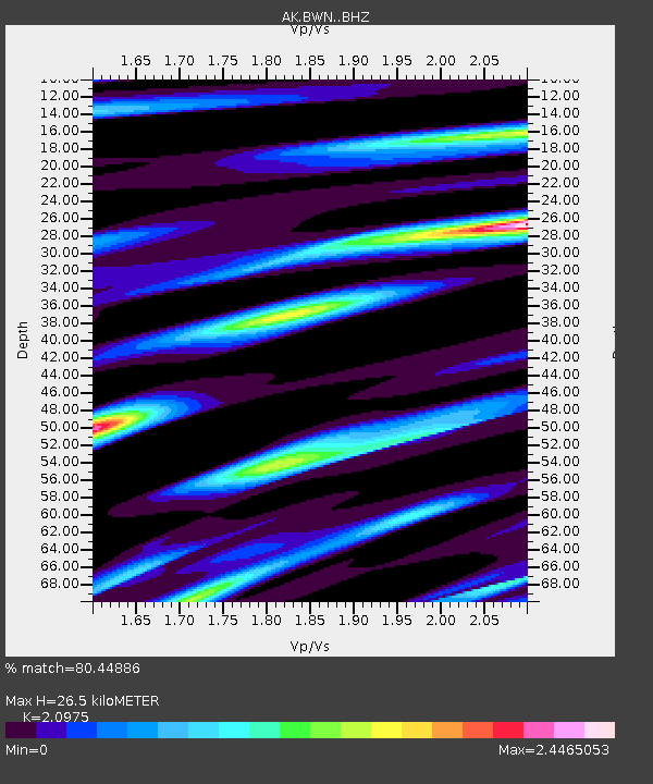
| Estimated Moho Depth: |
26.5 km |
| Estimated Crust Vp/Vs: |
2.10 |
| Assumed Crust Vp: |
6.566 km/s |
| Estimated Crust Vs: |
3.13 km/s |
| Estimated Crust Poisson's Ratio: |
0.35 |
|
| Radial Match: |
80.44886 % |
| Radial Bump: |
400 |
| Transverse Match: |
87.39889 % |
| Transverse Bump: |
400 |
| SOD ConfigId: |
13570011 |
| Insert Time: |
2019-04-30 06:28:35.432 +0000 |
| GWidth: |
2.5 |
| Max Bumps: |
400 |
| Tol: |
0.001 |
|

Signal To Noise
| Channel | StoN | STA | LTA |
| AK:BWN: :BHZ:20180517T18:49:30.488014Z | 19.190792 | 1.4121912E-6 | 7.358692E-8 |
| AK:BWN: :BHN:20180517T18:49:30.488014Z | 2.7295318 | 4.831452E-7 | 1.7700663E-7 |
| AK:BWN: :BHE:20180517T18:49:30.488014Z | 2.1012115 | 6.6935723E-7 | 3.1855777E-7 |
| Arrivals |
| Ps | 4.7 SECOND |
| PpPs | 12 SECOND |
| PsPs/PpSs | 16 SECOND |


