You are here: Home > Network List > TA - USArray Transportable Network (new EarthScope stations) Stations List
> Station J20A Shoshoni, WY, USA > Earthquake Result Viewer
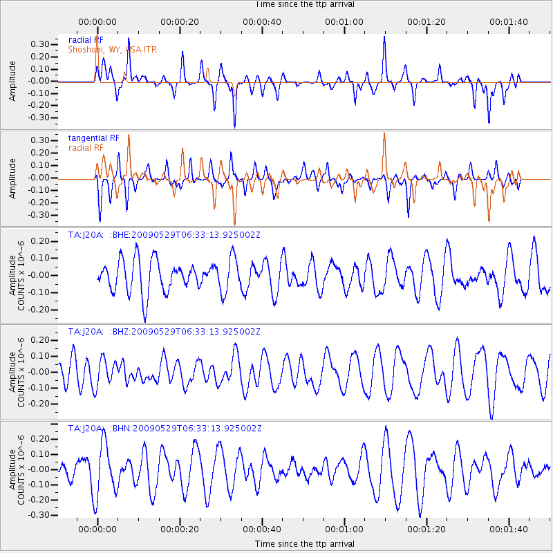
J20A Shoshoni, WY, USA - Earthquake Result Viewer
*The percent match for this event was below the threshold and hence no stack was calculated.
| Earthquake location: |
Vanuatu Islands |
| Earthquake latitude/longitude: |
-17.0/168.3 |
| Earthquake time(UTC): |
2009/05/29 (149) 06:20:14 GMT |
| Earthquake Depth: |
13 km |
| Earthquake Magnitude: |
5.5 MB, 5.5 MS, 5.7 MW, 5.6 MW |
| Earthquake Catalog/Contributor: |
WHDF/NEIC |
|
| Network: |
TA USArray Transportable Network (new EarthScope stations) |
| Station: |
J20A Shoshoni, WY, USA |
| Lat/Lon: |
43.35 N/108.08 W |
| Elevation: |
1500 m |
|
| Distance: |
97.0 deg |
| Az: |
46.907 deg |
| Baz: |
253.292 deg |
| Ray Param: |
$rayparam |
*The percent match for this event was below the threshold and hence was not used in the summary stack. |
|
| Radial Match: |
60.51195 % |
| Radial Bump: |
262 |
| Transverse Match: |
40.156532 % |
| Transverse Bump: |
251 |
| SOD ConfigId: |
2648 |
| Insert Time: |
2010-03-06 11:13:00.690 +0000 |
| GWidth: |
2.5 |
| Max Bumps: |
400 |
| Tol: |
0.001 |
|
Signal To Noise
| Channel | StoN | STA | LTA |
| TA:J20A: :BHZ:20090529T06:33:13.925002Z | 0.95726806 | 8.443182E-8 | 8.820081E-8 |
| TA:J20A: :BHN:20090529T06:33:13.925002Z | 1.7342734 | 1.7939225E-7 | 1.03439426E-7 |
| TA:J20A: :BHE:20090529T06:33:13.925002Z | 1.0990784 | 1.03195866E-7 | 9.3893085E-8 |
| Arrivals |
| Ps | |
| PpPs | |
| PsPs/PpSs | |


