You are here: Home > Network List > TA - USArray Transportable Network (new EarthScope stations) Stations List
> Station J20A Shoshoni, WY, USA > Earthquake Result Viewer
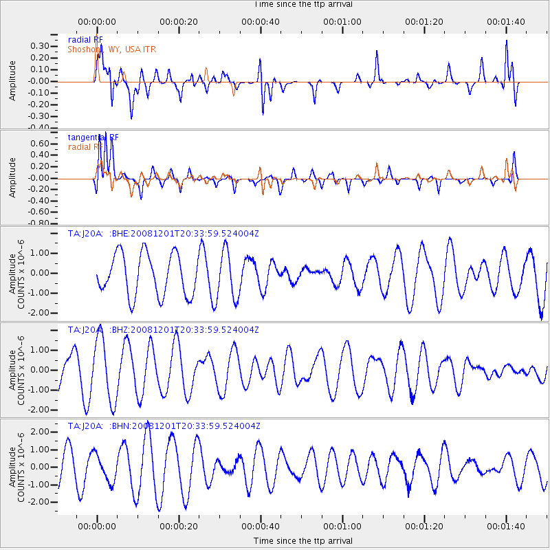
J20A Shoshoni, WY, USA - Earthquake Result Viewer
*The percent match for this event was below the threshold and hence no stack was calculated.
| Earthquake location: |
Tonga Islands Region |
| Earthquake latitude/longitude: |
-22.9/-175.2 |
| Earthquake time(UTC): |
2008/12/01 (336) 20:21:34 GMT |
| Earthquake Depth: |
39 km |
| Earthquake Magnitude: |
5.5 MB, 5.1 MS |
| Earthquake Catalog/Contributor: |
WHDF/NEIC |
|
| Network: |
TA USArray Transportable Network (new EarthScope stations) |
| Station: |
J20A Shoshoni, WY, USA |
| Lat/Lon: |
43.35 N/108.08 W |
| Elevation: |
1500 m |
|
| Distance: |
90.2 deg |
| Az: |
42.22 deg |
| Baz: |
238.128 deg |
| Ray Param: |
$rayparam |
*The percent match for this event was below the threshold and hence was not used in the summary stack. |
|
| Radial Match: |
60.418102 % |
| Radial Bump: |
400 |
| Transverse Match: |
68.16494 % |
| Transverse Bump: |
318 |
| SOD ConfigId: |
2658 |
| Insert Time: |
2010-03-06 11:13:03.605 +0000 |
| GWidth: |
2.5 |
| Max Bumps: |
400 |
| Tol: |
0.001 |
|
Signal To Noise
| Channel | StoN | STA | LTA |
| TA:J20A: :BHZ:20081201T20:33:59.524004Z | 2.3159213 | 1.617293E-6 | 6.983368E-7 |
| TA:J20A: :BHN:20081201T20:33:59.524004Z | 0.7207866 | 7.683369E-7 | 1.0659701E-6 |
| TA:J20A: :BHE:20081201T20:33:59.524004Z | 1.1683476 | 1.1989732E-6 | 1.0262129E-6 |
| Arrivals |
| Ps | |
| PpPs | |
| PsPs/PpSs | |


