You are here: Home > Network List > TA - USArray Transportable Network (new EarthScope stations) Stations List
> Station J20A Shoshoni, WY, USA > Earthquake Result Viewer
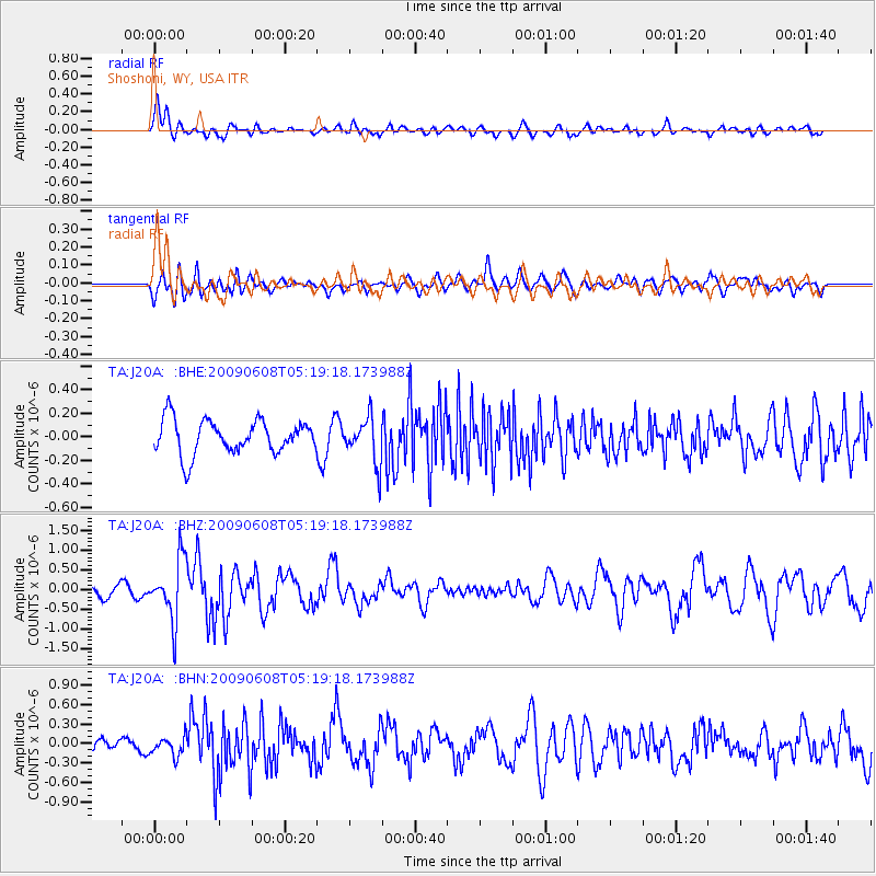
J20A Shoshoni, WY, USA - Earthquake Result Viewer
*The percent match for this event was below the threshold and hence no stack was calculated.
| Earthquake location: |
Honduras |
| Earthquake latitude/longitude: |
15.8/-86.9 |
| Earthquake time(UTC): |
2009/06/08 (159) 05:13:14 GMT |
| Earthquake Depth: |
10 km |
| Earthquake Magnitude: |
5.5 MB, 4.9 MS, 5.4 MW, 5.4 MW |
| Earthquake Catalog/Contributor: |
WHDF/NEIC |
|
| Network: |
TA USArray Transportable Network (new EarthScope stations) |
| Station: |
J20A Shoshoni, WY, USA |
| Lat/Lon: |
43.35 N/108.08 W |
| Elevation: |
1500 m |
|
| Distance: |
32.9 deg |
| Az: |
330.916 deg |
| Baz: |
140.092 deg |
| Ray Param: |
$rayparam |
*The percent match for this event was below the threshold and hence was not used in the summary stack. |
|
| Radial Match: |
73.41376 % |
| Radial Bump: |
400 |
| Transverse Match: |
48.798584 % |
| Transverse Bump: |
400 |
| SOD ConfigId: |
2648 |
| Insert Time: |
2010-03-06 11:13:05.991 +0000 |
| GWidth: |
2.5 |
| Max Bumps: |
400 |
| Tol: |
0.001 |
|
Signal To Noise
| Channel | StoN | STA | LTA |
| TA:J20A: :BHZ:20090608T05:19:18.173988Z | 6.9649086 | 7.596086E-7 | 1.0906225E-7 |
| TA:J20A: :BHN:20090608T05:19:18.173988Z | 0.92935663 | 1.421087E-7 | 1.5291084E-7 |
| TA:J20A: :BHE:20090608T05:19:18.173988Z | 1.3267193 | 1.9036823E-7 | 1.4348795E-7 |
| Arrivals |
| Ps | |
| PpPs | |
| PsPs/PpSs | |


